Resplendor geodata
Resplendor (Minas Gerais) is a populated place; located in Brazil in America/Sao_Paulo (GMT-3) time zone. With population of 15,131 people, there are 1205 cities with bigger population in this country. Compared to other cities in Brazil, 54% of cities are located further ↑North; 69.2% of cities are located further ←West and 72.4% of cities have higher elevation than Resplendor. Note1


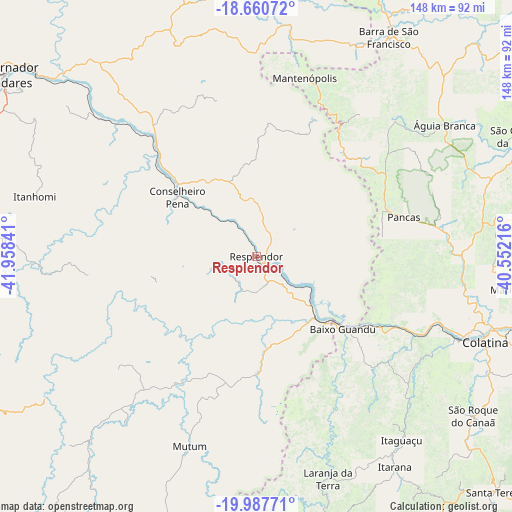
Resplendor GPS coordinates[2]
19° 19' 32.016" South, 41° 15' 19.008" West
| Map corner | latitude | longitude |
|---|---|---|
| Upper-left | -18.66072°, | -41.95841° |
| Center: | -19.32556°, | -41.25528° |
| Lower-right: | -19.98771°, | -40.55216° |
| Map W x H: | 147.5×147.5 km | = 91.7×91.7mi |
| max Lat: | 2.81972° ⇑54% North |
| Resplendor: | -19.32556° |
| min Lat: | ⇓46% South -33.69111° |
| min Long | Resplendor | max Long |
| -72.89583° | -41.25528° | -32.41083° |
| W 69.2%⇐ | ⇒30.8% E |
Elevation
Elevation of Resplendor is 99 m = 325 ft, and this is 281.9 m = 925 ft below average elevation for this country.
| Max E: |
1603 m = 5259 ft | 72.4% |
| Avg. | 380.9 m = 1250 ft | |
| Resplendor | 99 m = 325 ft | |
Min E: |
0 m = 0 ft | 27.6% |
See also: Brazil elevation on elevation.city.
Geographical zone
Resplendor is located in South Torrid zone (between Equator and Tropic of Capricorn). Distance of this Southern Tropic circle is 457.1 km =284 mi to South.| Distance of | km | miles | from Resplendor |
|---|---|---|---|
| Equator | 2148.8 | 1335.2 | to North |
| Tropic Capricorn | 457.1 | 284 | to South |
| Antarctic Circle | 5252.4 | 3263.7 | to South |
| South Pole | 7858.3 | 4882.9 | to South |


Nearby cities:
15 places around Resplendor: (largest is in red/bold)
• Afonso Cláudio
84.4 km =52.4 mi,  170°
170°
• Aimorés
27.6 km =17.1 mi,  133°
133°
• Baixo Guandu
33.1 km =20.6 mi, 130°
• Barra de São Francisco
74.1 km =46 mi,  31°
31°
• Colatina
69.7 km =43.3 mi,  109°
109°
• Conselheiro Pena
28.4 km =17.6 mi,  306°
306°
• Divino das Laranjeiras
65.3 km =40.6 mi,  338°
338°
• Itaguaçu
67.5 km =41.9 mi,  141°
141°
• Itarana
72.8 km =45.2 mi,  146°
146°
• Laranja da Terra
67.1 km =41.7 mi,  161°
161°
• Mantenópolis
53.3 km =33.1 mi,  15°
15°
• Marilândia
75.5 km =46.9 mi,  97°
97°
• Mutum
56.1 km =34.9 mi,  199°
199°
• Pancas
43.8 km =27.2 mi,  75°
75°
• Águia Branca
66.2 km =41.1 mi,  54°
54°
Sources, notices
• [Note1] Compared only with cities in Brazil existing in our database
• [Src1] Map data: © OpenStreetMap contributors (CC-BY-SA)
• [Src2] Other city data from geonames.org with taken over terms of usage.
• [Src3] Geographical zone / Annual Mean Temperature by Robert A. Rohde @ Wikipedia
