Águia Branca geodata
Águia Branca (Espírito Santo) is a populated place; located in Brazil in America/Sao_Paulo (GMT-3) time zone. With population of 2,554 people, there are 2000 cities with bigger population in this country. Compared to other cities in Brazil, 53.2% of cities are located further ↑North; 71.4% of cities are located further ←West and 67.9% of cities have higher elevation than Águia Branca. Note1


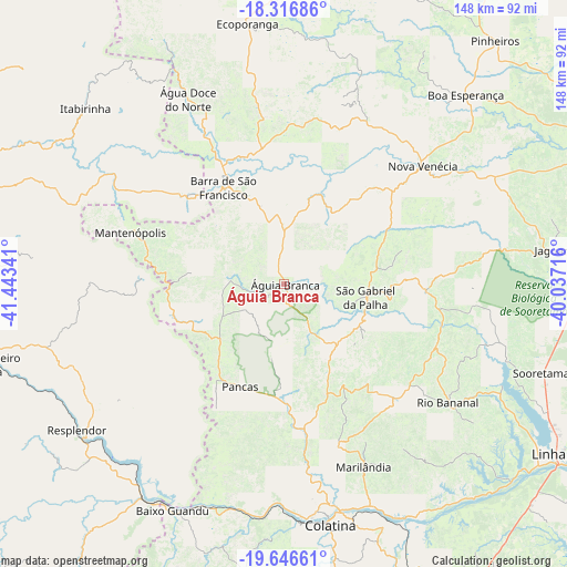
Águia Branca GPS coordinates[2]
18° 58' 59.016" South, 40° 44' 25.008" West
| Map corner | latitude | longitude |
|---|---|---|
| Upper-left | -18.31686°, | -41.44341° |
| Center: | -18.98306°, | -40.74028° |
| Lower-right: | -19.64661°, | -40.03716° |
| Map W x H: | 147.9×147.9 km | = 91.9×91.9mi |
| max Lat: | 2.81972° ⇑53.2% North |
| Águia Branca: | -18.98306° |
| min Lat: | ⇓46.8% South -33.69111° |
| min Long | Águia Branca | max Long |
| -72.89583° | -40.74028° | -32.41083° |
| W 71.4%⇐ | ⇒28.6% E |
Elevation
Elevation of Águia Branca is 143 m = 469 ft, and this is 237.9 m = 781 ft below average elevation for this country.
| Max E: |
1603 m = 5259 ft | 67.9% |
| Avg. | 380.9 m = 1250 ft | |
| Águia Branca | 143 m = 469 ft | |
Min E: |
0 m = 0 ft | 32.1% |
See also: Brazil elevation on elevation.city.
Geographical zone
Águia Branca is located in South Torrid zone (between Equator and Tropic of Capricorn). Distance of this Southern Tropic circle is 495.2 km =307.7 mi to South.| Distance of | km | miles | from Águia Branca |
|---|---|---|---|
| Equator | 2110.7 | 1311.5 | to North |
| Tropic Capricorn | 495.2 | 307.7 | to South |
| Antarctic Circle | 5290.5 | 3287.4 | to South |
| South Pole | 7896.3 | 4906.5 | to South |


Nearby cities:
15 places around Águia Branca: (largest is in red/bold)
• Aimorés
66.4 km =41.3 mi,  210°
210°
• Baixo Guandu
66.2 km =41.1 mi, 205°
• Barra de São Francisco
29.9 km =18.6 mi,  328°
328°
• Boa Esperança
67.9 km =42.2 mi,  43°
43°
• Colatina
62.9 km =39.1 mi,  169°
169°
• Conselheiro Pena
79.7 km =49.5 mi,  254°
254°
• Divino das Laranjeiras
81.1 km =50.4 mi,  286°
286°
• Ecoporanga
68.5 km =42.6 mi,  352°
352°
• Linhares
83.5 km =51.9 mi,  122°
122°
• Mantenópolis
42.4 km =26.3 mi, 288°
• Marilândia
52.1 km =32.4 mi,  156°
156°
• Nova Venécia
46.9 km =29.1 mi,  49°
49°
• Pancas
29.3 km =18.2 mi,  203°
203°
• Resplendor
66.2 km =41.1 mi,  234°
234°
• Rio Bananal
53 km =32.9 mi,  126°
126°
Sources, notices
• [Note1] Compared only with cities in Brazil existing in our database
• [Src1] Map data: © OpenStreetMap contributors (CC-BY-SA)
• [Src2] Other city data from geonames.org with taken over terms of usage.
• [Src3] Geographical zone / Annual Mean Temperature by Robert A. Rohde @ Wikipedia
