Pancas geodata
Pancas (Espírito Santo) is a populated place; located in Brazil in America/Sao_Paulo (GMT-3) time zone. With population of 8,183 people, there are 1763 cities with bigger population in this country. Compared to other cities in Brazil, 53.8% of cities are located further ↑North; 70.7% of cities are located further ←West and 70.5% of cities have higher elevation than Pancas. Note1


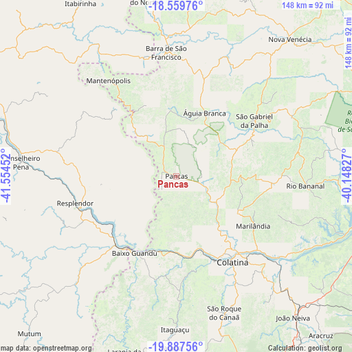
Pancas GPS coordinates[2]
19° 13' 30" South, 40° 51' 5.004" West
| Map corner | latitude | longitude |
|---|---|---|
| Upper-left | -18.55976°, | -41.55452° |
| Center: | -19.225°, | -40.85139° |
| Lower-right: | -19.88756°, | -40.14827° |
| Map W x H: | 147.6×147.6 km | = 91.7×91.7mi |
| max Lat: | 2.81972° ⇑53.8% North |
| Pancas: | -19.225° |
| min Lat: | ⇓46.2% South -33.69111° |
| min Long | Pancas | max Long |
| -72.89583° | -40.85139° | -32.41083° |
| W 70.7%⇐ | ⇒29.3% E |
Elevation
Elevation of Pancas is 119 m = 390 ft, and this is 261.9 m = 859 ft below average elevation for this country.
| Max E: |
1603 m = 5259 ft | 70.5% |
| Avg. | 380.9 m = 1250 ft | |
| Pancas | 119 m = 390 ft | |
Min E: |
0 m = 0 ft | 29.5% |
See also: Brazil elevation on elevation.city.
Geographical zone
Pancas is located in South Torrid zone (between Equator and Tropic of Capricorn). Distance of this Southern Tropic circle is 468.3 km =291 mi to South.| Distance of | km | miles | from Pancas |
|---|---|---|---|
| Equator | 2137.6 | 1328.2 | to North |
| Tropic Capricorn | 468.3 | 291 | to South |
| Antarctic Circle | 5263.6 | 3270.6 | to South |
| South Pole | 7869.4 | 4889.8 | to South |


Nearby cities:
15 places around Pancas: (largest is in red/bold)
• Aimorés
37.5 km =23.3 mi,  216°
216°
• Baixo Guandu
37 km =23 mi,  207°
207°
• Barra de São Francisco
52.4 km =32.6 mi,  355°
355°
• Colatina
41.9 km =26 mi,  146°
146°
• Conselheiro Pena
65.5 km =40.7 mi,  275°
275°
• Itaguaçu
64.2 km =39.9 mi,  180°
180°
• Itarana
72.2 km =44.9 mi, 181°
• João Neiva
76.7 km =47.7 mi,  140°
140°
• Laranja da Terra
78 km =48.5 mi,  196°
196°
• Mantenópolis
49.4 km =30.7 mi,  324°
324°
• Marilândia
38.6 km =24 mi,  122°
122°
• Nova Venécia
74.3 km =46.2 mi,  39°
39°
• Resplendor
43.8 km =27.2 mi,  255°
255°
• Rio Bananal
54.6 km =33.9 mi,  94°
94°
• Águia Branca
29.3 km =18.2 mi,  23°
23°
Sources, notices
• [Note1] Compared only with cities in Brazil existing in our database
• [Src1] Map data: © OpenStreetMap contributors (CC-BY-SA)
• [Src2] Other city data from geonames.org with taken over terms of usage.
• [Src3] Geographical zone / Annual Mean Temperature by Robert A. Rohde @ Wikipedia
