Pompéu geodata
Pompéu (Minas Gerais) is a populated place; located in Brazil in America/Sao_Paulo (GMT-3) time zone. With population of 25,277 people, there are 775 cities with bigger population in this country. Compared to other cities in Brazil, 53.8% of cities are located further ↑North; 51.6% of cities are located further ←West and 92.6% of cities have lower elevation than Pompéu. Note1


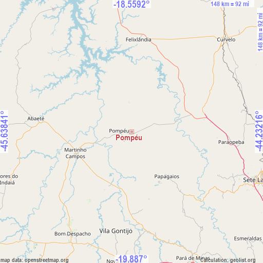
Pompéu GPS coordinates[2]
19° 13' 27.984" South, 44° 56' 7.008" West
| Map corner | latitude | longitude |
|---|---|---|
| Upper-left | -18.5592°, | -45.63841° |
| Center: | -19.22444°, | -44.93528° |
| Lower-right: | -19.887°, | -44.23216° |
| Map W x H: | 147.6×147.6 km | = 91.7×91.7mi |
| max Lat: | 2.81972° ⇑53.8% North |
| Pompéu: | -19.22444° |
| min Lat: | ⇓46.2% South -33.69111° |
| min Long | Pompéu | max Long |
| -72.89583° | -44.93528° | -32.41083° |
| W 51.6%⇐ | ⇒48.4% E |
Elevation
Elevation of Pompéu is 852 m = 2795 ft, and this is 471.1 m = 1546 ft above average elevation for this country.
| Max E: |
1603 m = 5259 ft | 7.4% |
| Pompéu | 852 m 2795 ft | |
| Avg. | 380.9 m = 1250 ft | |
Min E: |
0 m = 0 ft | 92.6% |
See also: Brazil elevation on elevation.city.
Geographical zone
Pompéu is located in South Torrid zone (between Equator and Tropic of Capricorn). Distance of this Southern Tropic circle is 468.4 km =291.1 mi to South.| Distance of | km | miles | from Pompéu |
|---|---|---|---|
| Equator | 2137.6 | 1328.2 | to North |
| Tropic Capricorn | 468.4 | 291.1 | to South |
| Antarctic Circle | 5263.6 | 3270.6 | to South |
| South Pole | 7869.5 | 4889.9 | to South |


Nearby cities:
15 places around Pompéu: (largest is in red/bold)
• Abaeté
54.1 km =33.6 mi,  277°
277°
• Bom Despacho
65.9 km =40.9 mi,  210°
210°
• Curvelo
74.3 km =46.2 mi,  45°
45°
• Dores do Indaiá
74.8 km =46.5 mi,  249°
249°
• Esmeraldas
88.4 km =54.9 mi,  132°
132°
• Itaúna
101.8 km =63.3 mi,  158°
158°
• Juatuba
102 km =63.4 mi,  142°
142°
• Luz
101.5 km =63.1 mi,  230°
230°
• Martinho Campos
33.8 km =21 mi, 249°
• Mateus Leme
100 km =62.1 mi,  147°
147°
• Matozinhos
96.9 km =60.2 mi,  112°
112°
• Papagaios
31.8 km =19.8 mi, 141°
• Pará de Minas
78.6 km =48.8 mi, 154°
• Pitangui
51.2 km =31.8 mi,  174°
174°
• Sete Lagoas
77.1 km =47.9 mi, 110°
Sources, notices
• [Note1] Compared only with cities in Brazil existing in our database
• [Src1] Map data: © OpenStreetMap contributors (CC-BY-SA)
• [Src2] Other city data from geonames.org with taken over terms of usage.
• [Src3] Geographical zone / Annual Mean Temperature by Robert A. Rohde @ Wikipedia
