Piracanjuba geodata
Piracanjuba (Goiás) is a populated place; located in Brazil in America/Sao_Paulo (GMT-3) time zone. With population of 16,736 people, there are 1108 cities with bigger population in this country. Compared to other cities in Brazil, 50.4% of cities are located further ↓South; 71.5% of cities are located further →East and 83.4% of cities have lower elevation than Piracanjuba. Note1


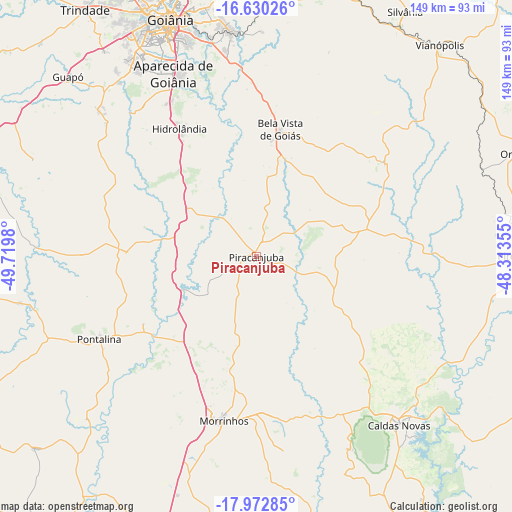
Piracanjuba GPS coordinates[2]
17° 18' 10.008" South, 49° 1' 0.012" West
| Map corner | latitude | longitude |
|---|---|---|
| Upper-left | -16.63026°, | -49.7198° |
| Center: | -17.30278°, | -49.01667° |
| Lower-right: | -17.97285°, | -48.31355° |
| Map W x H: | 149.3×149.3 km | = 92.8×92.8mi |
| max Lat: | 2.81972° ⇑49.6% North |
| Piracanjuba: | -17.30278° |
| min Lat: | ⇓50.4% South -33.69111° |
| min Long | Piracanjuba | max Long |
| -72.89583° | -49.01667° | -32.41083° |
| W 28.5%⇐ | ⇒71.5% E |
Elevation
Elevation of Piracanjuba is 737 m = 2418 ft, and this is 356.1 m = 1168 ft above average elevation for this country.
| Max E: |
1603 m = 5259 ft | 16.6% |
| Piracanjuba | 737 m 2418 ft | |
| Avg. | 380.9 m = 1250 ft | |
Min E: |
0 m = 0 ft | 83.4% |
See also: Brazil elevation on elevation.city.
Geographical zone
Piracanjuba is located in South Torrid zone (between Equator and Tropic of Capricorn). Distance of this Southern Tropic circle is 682 km =423.8 mi to South.| Distance of | km | miles | from Piracanjuba |
|---|---|---|---|
| Equator | 1923.9 | 1195.5 | to North |
| Tropic Capricorn | 682 | 423.8 | to South |
| Antarctic Circle | 5477.3 | 3403.4 | to South |
| South Pole | 8083.2 | 5022.7 | to South |


Nearby cities:
15 places around Piracanjuba: (largest is in red/bold)
• Aparecida de Goiânia
58.5 km =36.4 mi,  335°
335°
• Bela Vista de Goiás
37.3 km =23.2 mi,  10°
10°
• Caldas Novas
64.1 km =39.8 mi,  139°
139°
• Goianápolis
88.1 km =54.7 mi,  359°
359°
• Goiatuba
86.7 km =53.9 mi,  204°
204°
• Goiânia
73.8 km =45.9 mi, 340°
• Guapó
75.9 km =47.2 mi,  313°
313°
• Hidrolândia
44 km =27.3 mi,  329°
329°
• Morrinhos
48.4 km =30.1 mi,  190°
190°
• Orizona
82.3 km =51.1 mi,  68°
68°
• Pires do Rio
78.3 km =48.7 mi,  89°
89°
• Pontalina
51.9 km =32.2 mi,  241°
241°
• Senador Canedo
66.6 km =41.4 mi,  352°
352°
• Silvânia
83.7 km =52 mi,  31°
31°
• Vianópolis
82 km =51 mi,  40°
40°
Sources, notices
• [Note1] Compared only with cities in Brazil existing in our database
• [Src1] Map data: © OpenStreetMap contributors (CC-BY-SA)
• [Src2] Other city data from geonames.org with taken over terms of usage.
• [Src3] Geographical zone / Annual Mean Temperature by Robert A. Rohde @ Wikipedia
