Aparecida de Goiânia geodata
Aparecida de Goiânia (Goiás) is a populated place; located in Brazil in America/Sao_Paulo (GMT-3) time zone. With population of 510,770 people, there are 33 cities with bigger population in this country. Compared to other cities in Brazil, 51.3% of cities are located further ↓South; 73.5% of cities are located further →East and 91.1% of cities have lower elevation than Aparecida de Goiânia. Note1


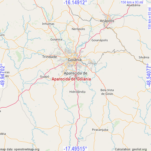
Aparecida de Goiânia GPS coordinates[2]
16° 49' 23.988" South, 49° 14' 38.004" West
| Map corner | latitude | longitude |
|---|---|---|
| Upper-left | -16.14912°, | -49.94702° |
| Center: | -16.82333°, | -49.24389° |
| Lower-right: | -17.49515°, | -48.54077° |
| Map W x H: | 149.7×149.7 km | = 93×93mi |
| max Lat: | 2.81972° ⇑48.7% North |
| Aparecida de Goiânia: | -16.82333° |
| min Lat: | ⇓51.3% South -33.69111° |
| min Long | Aparecida de Go | max Long |
| -72.89583° | -49.24389° | -32.41083° |
| W 26.5%⇐ | ⇒73.5% E |
Elevation
Elevation of Aparecida de Goiânia is 829 m = 2720 ft, and this is 448.1 m = 1470 ft above average elevation for this country.
| Max E: |
1603 m = 5259 ft | 8.9% |
| Aparecida de Goiânia | 829 m 2720 ft | |
| Avg. | 380.9 m = 1250 ft | |
Min E: |
0 m = 0 ft | 91.1% |
See also: Aparecida de Goiânia elevation on elevation.city.
Geographical zone
Aparecida de Goiânia is located in South Torrid zone (between Equator and Tropic of Capricorn). Distance of this Southern Tropic circle is 735.3 km =456.9 mi to South.| Distance of | km | miles | from Aparecida de Goiânia |
|---|---|---|---|
| Equator | 1870.6 | 1162.3 | to North |
| Tropic Capricorn | 735.3 | 456.9 | to South |
| Antarctic Circle | 5530.6 | 3436.6 | to South |
| South Pole | 8136.5 | 5055.8 | to South |


Nearby cities:
15 places around Aparecida de Goiânia: (largest is in red/bold)
• Anápolis
63.3 km =39.3 mi,  29°
29°
• Bela Vista de Goiás
35.1 km =21.8 mi,  118°
118°
• Goianira
41.3 km =25.7 mi,  331°
331°
• Goianápolis
41.9 km =26 mi, 33°
• Goiânia
16.1 km =10 mi,  356°
356°
• Guapó
30.7 km =19.1 mi,  268°
268°
• Hidrolândia
15.5 km =9.6 mi,  173°
173°
• Inhumas
58.3 km =36.2 mi, 332°
• Nerópolis
46.4 km =28.8 mi,  3°
3°
• Palmeiras de Goiás
72.6 km =45.1 mi, 271°
• Piracanjuba
58.5 km =36.4 mi,  155°
155°
• Senador Canedo
20.5 km =12.7 mi,  51°
51°
• Silvânia
70.1 km =43.6 mi,  74°
74°
• Trindade
32.5 km =20.2 mi,  306°
306°
• Vianópolis
78 km =48.5 mi,  83°
83°
Sources, notices
• [Note1] Compared only with cities in Brazil existing in our database
• [Src1] Map data: © OpenStreetMap contributors (CC-BY-SA)
• [Src2] Other city data from geonames.org with taken over terms of usage.
• [Src3] Geographical zone / Annual Mean Temperature by Robert A. Rohde @ Wikipedia
