Silvânia geodata
Silvânia (Goiás) is a populated place; located in Brazil in America/Sao_Paulo (GMT-3) time zone. With population of 11,377 people, there are 1532 cities with bigger population in this country. Compared to other cities in Brazil, 51.6% of cities are located further ↓South; 68.6% of cities are located further →East and 95.4% of cities have lower elevation than Silvânia. Note1


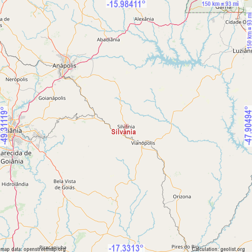
Silvânia GPS coordinates[2]
16° 39' 32.004" South, 48° 36' 29.016" West
| Map corner | latitude | longitude |
|---|---|---|
| Upper-left | -15.98411°, | -49.31119° |
| Center: | -16.65889°, | -48.60806° |
| Lower-right: | -17.3313°, | -47.90494° |
| Map W x H: | 149.8×149.8 km | = 93.1×93.1mi |
| max Lat: | 2.81972° ⇑48.4% North |
| Silvânia: | -16.65889° |
| min Lat: | ⇓51.6% South -33.69111° |
| min Long | Silvânia | max Long |
| -72.89583° | -48.60806° | -32.41083° |
| W 31.4%⇐ | ⇒68.6% E |
Elevation
Elevation of Silvânia is 903 m = 2963 ft, and this is 522.1 m = 1713 ft above average elevation for this country.
| Max E: |
1603 m = 5259 ft | 4.6% |
| Silvânia | 903 m 2963 ft | |
| Avg. | 380.9 m = 1250 ft | |
Min E: |
0 m = 0 ft | 95.4% |
See also: Brazil elevation on elevation.city.
Geographical zone
Silvânia is located in South Torrid zone (between Equator and Tropic of Capricorn). Distance of this Southern Tropic circle is 753.6 km =468.3 mi to South.| Distance of | km | miles | from Silvânia |
|---|---|---|---|
| Equator | 1852.3 | 1151 | to North |
| Tropic Capricorn | 753.6 | 468.3 | to South |
| Antarctic Circle | 5548.9 | 3447.9 | to South |
| South Pole | 8154.8 | 5067.2 | to South |


Nearby cities:
15 places around Silvânia: (largest is in red/bold)
• Abadiânia
51.6 km =32.1 mi,  348°
348°
• Anápolis
52.1 km =32.4 mi,  315°
315°
• Aparecida de Goiânia
70.1 km =43.6 mi,  254°
254°
• Bela Vista de Goiás
50.7 km =31.5 mi,  226°
226°
• Goianira
89.1 km =55.4 mi,  281°
281°
• Goianápolis
47.3 km =29.4 mi,  290°
290°
• Goiânia
68.8 km =42.8 mi,  268°
268°
• Hidrolândia
74.1 km =46 mi,  242°
242°
• Luziânia
83.4 km =51.8 mi,  57°
57°
• Nerópolis
70.9 km =44.1 mi, 293°
• Orizona
53.1 km =33 mi,  141°
141°
• Piracanjuba
83.7 km =52 mi,  211°
211°
• Pires do Rio
79.4 km =49.3 mi,  153°
153°
• Senador Canedo
51.9 km =32.2 mi,  263°
263°
• Vianópolis
13.4 km =8.3 mi,  133°
133°
Sources, notices
• [Note1] Compared only with cities in Brazil existing in our database
• [Src1] Map data: © OpenStreetMap contributors (CC-BY-SA)
• [Src2] Other city data from geonames.org with taken over terms of usage.
• [Src3] Geographical zone / Annual Mean Temperature by Robert A. Rohde @ Wikipedia
