Orizona geodata
Orizona (Goiás) is a populated place; located in Brazil in America/Sao_Paulo (GMT-3) time zone. With population of 7,583 people, there are 1798 cities with bigger population in this country. Compared to other cities in Brazil, 50.9% of cities are located further ↓South; 66% of cities are located further →East and 89.8% of cities have lower elevation than Orizona. Note1


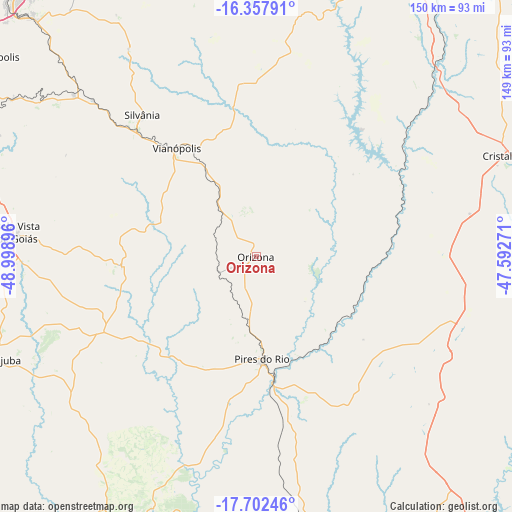
Orizona GPS coordinates[2]
17° 1' 53.004" South, 48° 17' 44.988" West
| Map corner | latitude | longitude |
|---|---|---|
| Upper-left | -16.35791°, | -48.99896° |
| Center: | -17.03139°, | -48.29583° |
| Lower-right: | -17.70246°, | -47.59271° |
| Map W x H: | 149.5×149.5 km | = 92.9×92.9mi |
| max Lat: | 2.81972° ⇑49.1% North |
| Orizona: | -17.03139° |
| min Lat: | ⇓50.9% South -33.69111° |
| min Long | Orizona | max Long |
| -72.89583° | -48.29583° | -32.41083° |
| W 34%⇐ | ⇒66% E |
Elevation
Elevation of Orizona is 810 m = 2657 ft, and this is 429.1 m = 1408 ft above average elevation for this country.
| Max E: |
1603 m = 5259 ft | 10.2% |
| Orizona | 810 m 2657 ft | |
| Avg. | 380.9 m = 1250 ft | |
Min E: |
0 m = 0 ft | 89.8% |
See also: Brazil elevation on elevation.city.
Geographical zone
Orizona is located in South Torrid zone (between Equator and Tropic of Capricorn). Distance of this Southern Tropic circle is 712.2 km =442.5 mi to South.| Distance of | km | miles | from Orizona |
|---|---|---|---|
| Equator | 1893.7 | 1176.7 | to North |
| Tropic Capricorn | 712.2 | 442.5 | to South |
| Antarctic Circle | 5507.5 | 3422.2 | to South |
| South Pole | 8113.3 | 5041.4 | to South |


Nearby cities:
15 places around Orizona: (largest is in red/bold)
• Abadiânia
101.9 km =63.3 mi,  334°
334°
• Anápolis
105.1 km =65.3 mi,  318°
318°
• Aparecida de Goiânia
103.5 km =64.3 mi,  282°
282°
• Bela Vista de Goiás
70.2 km =43.6 mi, 275°
• Caldas Novas
86.7 km =53.9 mi,  203°
203°
• Cristalina
78.1 km =48.5 mi,  67°
67°
• Goianápolis
96.8 km =60.1 mi,  306°
306°
• Hidrolândia
99.4 km =61.8 mi,  274°
274°
• Ipameri
78.1 km =48.5 mi,  169°
169°
• Luziânia
94.1 km =58.5 mi,  23°
23°
• Piracanjuba
82.3 km =51.1 mi,  248°
248°
• Pires do Rio
29.9 km =18.6 mi,  176°
176°
• Senador Canedo
92.1 km =57.2 mi,  292°
292°
• Silvânia
53.1 km =33 mi, 321°
• Vianópolis
39.8 km =24.7 mi, 323°
Sources, notices
• [Note1] Compared only with cities in Brazil existing in our database
• [Src1] Map data: © OpenStreetMap contributors (CC-BY-SA)
• [Src2] Other city data from geonames.org with taken over terms of usage.
• [Src3] Geographical zone / Annual Mean Temperature by Robert A. Rohde @ Wikipedia
