Caldas Novas geodata
Caldas Novas (Goiás) is a seat of a second-order administrative division; located in Brazil in America/Sao_Paulo (GMT-3) time zone. With population of 63,675 people, there are 350 cities with bigger population in this country. Compared to other cities in Brazil, 50.5% of cities are located further ↑North; 68.8% of cities are located further →East and 80.3% of cities have lower elevation than Caldas Novas. Note1


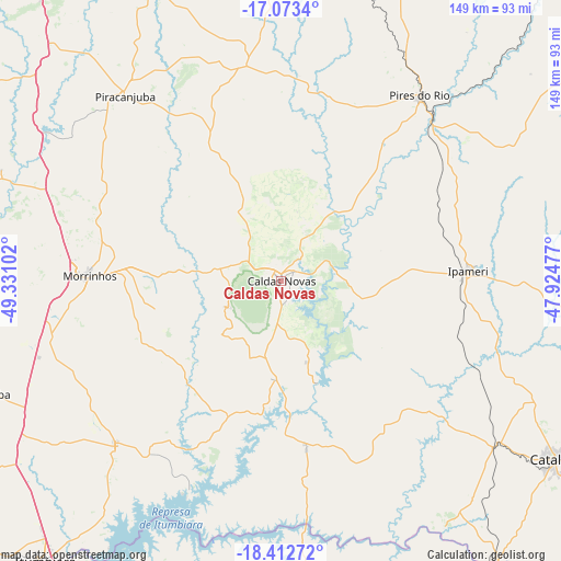
Caldas Novas GPS coordinates[2]
17° 44' 39.516" South, 48° 37' 40.404" West
| Map corner | latitude | longitude |
|---|---|---|
| Upper-left | -17.0734°, | -49.33102° |
| Center: | -17.74431°, | -48.62789° |
| Lower-right: | -18.41272°, | -47.92477° |
| Map W x H: | 148.9×148.9 km | = 92.5×92.5mi |
| max Lat: | 2.81972° ⇑50.5% North |
| Caldas Novas: | -17.74431° |
| min Lat: | ⇓49.5% South -33.69111° |
| min Long | Caldas Novas | max Long |
| -72.89583° | -48.62789° | -32.41083° |
| W 31.2%⇐ | ⇒68.8% E |
Elevation
Elevation of Caldas Novas is 695 m = 2280 ft, and this is 314.1 m = 1031 ft above average elevation for this country.
| Max E: |
1603 m = 5259 ft | 19.7% |
| Caldas Novas | 695 m 2280 ft | |
| Avg. | 380.9 m = 1250 ft | |
Min E: |
0 m = 0 ft | 80.3% |
See also: Caldas Novas elevation on elevation.city.
Geographical zone
Caldas Novas is located in South Torrid zone (between Equator and Tropic of Capricorn). Distance of this Southern Tropic circle is 632.9 km =393.3 mi to South.| Distance of | km | miles | from Caldas Novas |
|---|---|---|---|
| Equator | 1973 | 1226 | to North |
| Tropic Capricorn | 632.9 | 393.3 | to South |
| Antarctic Circle | 5428.2 | 3372.9 | to South |
| South Pole | 8034.1 | 4992.2 | to South |


Nearby cities:
15 places around Caldas Novas: (largest is in red/bold)
• Araguari
110.7 km =68.8 mi,  155°
155°
• Bela Vista de Goiás
92.5 km =57.5 mi,  338°
338°
• Buriti Alegre
62 km =38.5 mi,  224°
224°
• Catalão
86 km =53.4 mi,  123°
123°
• Centralina
111.2 km =69.1 mi,  212°
212°
• Goiatuba
82.5 km =51.3 mi,  248°
248°
• Hidrolândia
107.8 km =67 mi,  323°
323°
• Ipameri
49.6 km =30.8 mi,  87°
87°
• Itumbiara
97.4 km =60.5 mi, 219°
• Morrinhos
50 km =31.1 mi,  271°
271°
• Orizona
86.7 km =53.9 mi,  23°
23°
• Piracanjuba
64.1 km =39.8 mi, 319°
• Pires do Rio
61.7 km =38.3 mi,  36°
36°
• Pontalina
90.2 km =56 mi,  285°
285°
• Tupaciguara
94.6 km =58.8 mi,  184°
184°
Sources, notices
• [Note1] Compared only with cities in Brazil existing in our database
• [Src1] Map data: © OpenStreetMap contributors (CC-BY-SA)
• [Src2] Other city data from geonames.org with taken over terms of usage.
• [Src3] Geographical zone / Annual Mean Temperature by Robert A. Rohde @ Wikipedia
