Hidrolândia geodata
Hidrolândia (Goiás) is a populated place; located in Brazil in America/Sao_Paulo (GMT-3) time zone. With population of 7,082 people, there are 1824 cities with bigger population in this country. Compared to other cities in Brazil, 51% of cities are located further ↓South; 73.4% of cities are located further →East and 90.7% of cities have lower elevation than Hidrolândia. Note1


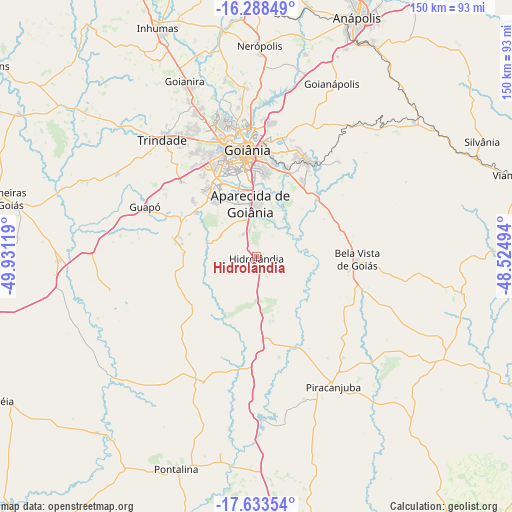
Hidrolândia GPS coordinates[2]
16° 57' 43.992" South, 49° 13' 41.016" West
| Map corner | latitude | longitude |
|---|---|---|
| Upper-left | -16.28849°, | -49.93119° |
| Center: | -16.96222°, | -49.22806° |
| Lower-right: | -17.63354°, | -48.52494° |
| Map W x H: | 149.6×149.6 km | = 93×93mi |
| max Lat: | 2.81972° ⇑49% North |
| Hidrolândia: | -16.96222° |
| min Lat: | ⇓51% South -33.69111° |
| min Long | Hidrolândia | max Long |
| -72.89583° | -49.22806° | -32.41083° |
| W 26.6%⇐ | ⇒73.4% E |
Elevation
Elevation of Hidrolândia is 824 m = 2703 ft, and this is 443.1 m = 1454 ft above average elevation for this country.
| Max E: |
1603 m = 5259 ft | 9.3% |
| Hidrolândia | 824 m 2703 ft | |
| Avg. | 380.9 m = 1250 ft | |
Min E: |
0 m = 0 ft | 90.7% |
See also: Brazil elevation on elevation.city.
Geographical zone
Hidrolândia is located in South Torrid zone (between Equator and Tropic of Capricorn). Distance of this Southern Tropic circle is 719.9 km =447.3 mi to South.| Distance of | km | miles | from Hidrolândia |
|---|---|---|---|
| Equator | 1886 | 1171.9 | to North |
| Tropic Capricorn | 719.9 | 447.3 | to South |
| Antarctic Circle | 5515.2 | 3427 | to South |
| South Pole | 8121 | 5046.2 | to South |


Nearby cities:
15 places around Hidrolândia: (largest is in red/bold)
• Anápolis
76.5 km =47.5 mi,  22°
22°
• Aparecida de Goiânia
15.5 km =9.6 mi,  353°
353°
• Bela Vista de Goiás
29.2 km =18.1 mi,  92°
92°
• Goianira
56 km =34.8 mi,  337°
337°
• Goianápolis
54.7 km =34 mi, 23°
• Goiânia
31.7 km =19.7 mi,  355°
355°
• Guapó
35.5 km =22.1 mi,  294°
294°
• Inhumas
73 km =45.4 mi, 336°
• Nerópolis
61.8 km =38.4 mi,  0°
0°
• Palmeiras de Goiás
76.3 km =47.4 mi,  283°
283°
• Piracanjuba
44 km =27.3 mi,  149°
149°
• Pontalina
66.8 km =41.5 mi,  200°
200°
• Senador Canedo
31.7 km =19.7 mi,  26°
26°
• Silvânia
74.1 km =46 mi,  62°
62°
• Trindade
44.5 km =27.7 mi,  321°
321°
Sources, notices
• [Note1] Compared only with cities in Brazil existing in our database
• [Src1] Map data: © OpenStreetMap contributors (CC-BY-SA)
• [Src2] Other city data from geonames.org with taken over terms of usage.
• [Src3] Geographical zone / Annual Mean Temperature by Robert A. Rohde @ Wikipedia
