Goiatuba geodata
Goiatuba (Goiás) is a populated place; located in Brazil in America/Sao_Paulo (GMT-3) time zone. With population of 25,925 people, there are 759 cities with bigger population in this country. Compared to other cities in Brazil, 51.1% of cities are located further ↑North; 74.4% of cities are located further →East and 86.1% of cities have lower elevation than Goiatuba. Note1


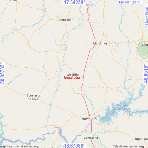
Goiatuba GPS coordinates[2]
18° 0' 45" South, 49° 21' 16.992" West
| Map corner | latitude | longitude |
|---|---|---|
| Upper-left | -17.34258°, | -50.05785° |
| Center: | -18.0125°, | -49.35472° |
| Lower-right: | -18.67988°, | -48.6516° |
| Map W x H: | 148.7×148.7 km | = 92.4×92.4mi |
| max Lat: | 2.81972° ⇑51.1% North |
| Goiatuba: | -18.0125° |
| min Lat: | ⇓48.9% South -33.69111° |
| min Long | Goiatuba | max Long |
| -72.89583° | -49.35472° | -32.41083° |
| W 25.6%⇐ | ⇒74.4% E |
Elevation
Elevation of Goiatuba is 768 m = 2520 ft, and this is 387.1 m = 1270 ft above average elevation for this country.
| Max E: |
1603 m = 5259 ft | 13.9% |
| Goiatuba | 768 m 2520 ft | |
| Avg. | 380.9 m = 1250 ft | |
Min E: |
0 m = 0 ft | 86.1% |
See also: Brazil elevation on elevation.city.
Geographical zone
Goiatuba is located in South Torrid zone (between Equator and Tropic of Capricorn). Distance of this Southern Tropic circle is 603.1 km =374.7 mi to South.| Distance of | km | miles | from Goiatuba |
|---|---|---|---|
| Equator | 2002.8 | 1244.5 | to North |
| Tropic Capricorn | 603.1 | 374.7 | to South |
| Antarctic Circle | 5398.4 | 3354.4 | to South |
| South Pole | 8004.3 | 4973.6 | to South |


Nearby cities:
15 places around Goiatuba: (largest is in red/bold)
• Bela Vista de Goiás
123.2 km =76.6 mi,  20°
20°
• Buriti Alegre
36.1 km =22.4 mi,  113°
113°
• Caldas Novas
82.5 km =51.3 mi,  68°
68°
• Capinópolis
77.8 km =48.3 mi,  196°
196°
• Centralina
65.6 km =40.8 mi,  165°
165°
• Edéia
96.7 km =60.1 mi,  320°
320°
• Hidrolândia
117.6 km =73.1 mi,  6°
6°
• Ituiutaba
107.5 km =66.8 mi,  186°
186°
• Itumbiara
47.6 km =29.6 mi,  161°
161°
• Monte Alegre de Minas
107.7 km =66.9 mi,  152°
152°
• Morrinhos
41.3 km =25.7 mi,  40°
40°
• Piracanjuba
86.7 km =53.9 mi, 24°
• Pontalina
55.1 km =34.2 mi,  349°
349°
• Santa Vitória
122.4 km =76.1 mi,  221°
221°
• Tupaciguara
94.1 km =58.5 mi,  133°
133°
Sources, notices
• [Note1] Compared only with cities in Brazil existing in our database
• [Src1] Map data: © OpenStreetMap contributors (CC-BY-SA)
• [Src2] Other city data from geonames.org with taken over terms of usage.
• [Src3] Geographical zone / Annual Mean Temperature by Robert A. Rohde @ Wikipedia
