Guaratinguetá geodata
Guaratinguetá (São Paulo) is a populated place; located in Brazil in America/Sao_Paulo (GMT-3) time zone. With population of 105,880 people, there are 217 cities with bigger population in this country. Compared to other cities in Brazil, 76.8% of cities are located further ↑North; 50.5% of cities are located further ←West and 67.1% of cities have lower elevation than Guaratinguetá. Note1


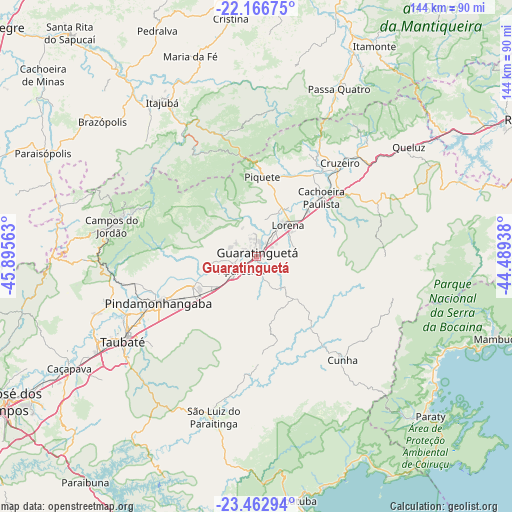
Guaratinguetá GPS coordinates[2]
22° 48' 59.004" South, 45° 11' 33" West
| Map corner | latitude | longitude |
|---|---|---|
| Upper-left | -22.16675°, | -45.89563° |
| Center: | -22.81639°, | -45.1925° |
| Lower-right: | -23.46294°, | -44.48938° |
| Map W x H: | 144.1×144.1 km | = 89.5×89.5mi |
| max Lat: | 2.81972° ⇑76.8% North |
| Guaratinguetá: | -22.81639° |
| min Lat: | ⇓23.2% South -33.69111° |
| min Long | Guaratinguetá | max Long |
| -72.89583° | -45.1925° | -32.41083° |
| W 50.5%⇐ | ⇒49.5% E |
Elevation
Elevation of Guaratinguetá is 545 m = 1788 ft, and this is 164.1 m = 538 ft above average elevation for this country.
| Max E: |
1603 m = 5259 ft | 32.9% |
| Guaratinguetá | 545 m 1788 ft | |
| Avg. | 380.9 m = 1250 ft | |
Min E: |
0 m = 0 ft | 67.1% |
See also: Guaratinguetá elevation on elevation.city.
Geographical zone
Guaratinguetá is located in South Torrid zone (between Equator and Tropic of Capricorn). Distance of this Southern Tropic circle is 69 km =42.9 mi to South.| Distance of | km | miles | from Guaratinguetá |
|---|---|---|---|
| Equator | 2536.9 | 1576.4 | to North |
| Tropic Capricorn | 69 | 42.9 | to South |
| Antarctic Circle | 4864.2 | 3022.5 | to South |
| South Pole | 7470.1 | 4641.7 | to South |


Nearby cities:
15 places around Guaratinguetá: (largest is in red/bold)
• Aparecida
5.1 km =3.2 mi,  228°
228°
• Campos do Jordão
41.8 km =26 mi,  281°
281°
• Caçapava
61.4 km =38.2 mi,  239°
239°
• Cruzeiro
35.3 km =21.9 mi,  40°
40°
• Cunha
37.3 km =23.2 mi,  140°
140°
• Itajubá
51 km =31.7 mi,  328°
328°
• Itanhandu
63.6 km =39.5 mi,  24°
24°
• Lorena
11.8 km =7.3 mi, 36°
• Paraisópolis
67 km =41.6 mi,  295°
295°
• Paraty
66.3 km =41.2 mi,  132°
132°
• Passa Quatro
52.7 km =32.7 mi,  26°
26°
• Pindamonhangaba
30.1 km =18.7 mi,  246°
246°
• Piquete
22.6 km =14 mi,  4°
4°
• Taubaté
43.9 km =27.3 mi, 237°
• Tremembé
39.8 km =24.7 mi, 246°
Sources, notices
• [Note1] Compared only with cities in Brazil existing in our database
• [Src1] Map data: © OpenStreetMap contributors (CC-BY-SA)
• [Src2] Other city data from geonames.org with taken over terms of usage.
• [Src3] Geographical zone / Annual Mean Temperature by Robert A. Rohde @ Wikipedia
