Lorena geodata
Lorena (São Paulo) is a populated place; located in Brazil in America/Sao_Paulo (GMT-3) time zone. With population of 76,506 people, there are 299 cities with bigger population in this country. Compared to other cities in Brazil, 75.7% of cities are located further ↑North; 50.8% of cities are located further ←West and 65.5% of cities have lower elevation than Lorena. Note1


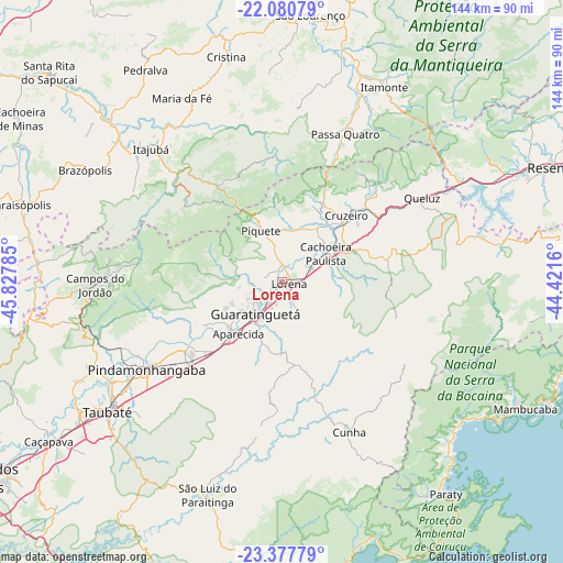
Lorena GPS coordinates[2]
22° 43' 50.988" South, 45° 7' 28.992" West
| Map corner | latitude | longitude |
|---|---|---|
| Upper-left | -22.08079°, | -45.82785° |
| Center: | -22.73083°, | -45.12472° |
| Lower-right: | -23.37779°, | -44.4216° |
| Map W x H: | 144.2×144.2 km | = 89.6×89.6mi |
| max Lat: | 2.81972° ⇑75.7% North |
| Lorena: | -22.73083° |
| min Lat: | ⇓24.3% South -33.69111° |
| min Long | Lorena | max Long |
| -72.89583° | -45.12472° | -32.41083° |
| W 50.8%⇐ | ⇒49.2% E |
Elevation
Elevation of Lorena is 529 m = 1736 ft, and this is 148.1 m = 486 ft above average elevation for this country.
| Max E: |
1603 m = 5259 ft | 34.5% |
| Lorena | 529 m 1736 ft | |
| Avg. | 380.9 m = 1250 ft | |
Min E: |
0 m = 0 ft | 65.5% |
See also: Lorena elevation on elevation.city.
Geographical zone
Lorena is located in South Torrid zone (between Equator and Tropic of Capricorn). Distance of this Southern Tropic circle is 78.5 km =48.8 mi to South.| Distance of | km | miles | from Lorena |
|---|---|---|---|
| Equator | 2527.4 | 1570.5 | to North |
| Tropic Capricorn | 78.5 | 48.8 | to South |
| Antarctic Circle | 4873.7 | 3028.4 | to South |
| South Pole | 7479.6 | 4647.6 | to South |


Nearby cities:
15 places around Lorena: (largest is in red/bold)
• Aparecida
16.8 km =10.4 mi,  219°
219°
• Campos do Jordão
47.9 km =29.8 mi,  268°
268°
• Cruzeiro
23.6 km =14.7 mi,  41°
41°
• Cunha
41.8 km =26 mi,  156°
156°
• Guaratinguetá
11.8 km =7.3 mi, 216°
• Itajubá
47.8 km =29.7 mi,  315°
315°
• Itanhandu
52.2 km =32.4 mi,  21°
21°
• Itatiaia
63.3 km =39.3 mi,  65°
65°
• Paraty
68.6 km =42.6 mi,  142°
142°
• Passa Quatro
41.2 km =25.6 mi, 23°
• Pindamonhangaba
40.7 km =25.3 mi,  238°
238°
• Piquete
14.1 km =8.8 mi,  337°
337°
• São Lourenço
68.7 km =42.7 mi,  6°
6°
• Taubaté
55 km =34.2 mi,  233°
233°
• Tremembé
50.3 km =31.3 mi, 239°
Sources, notices
• [Note1] Compared only with cities in Brazil existing in our database
• [Src1] Map data: © OpenStreetMap contributors (CC-BY-SA)
• [Src2] Other city data from geonames.org with taken over terms of usage.
• [Src3] Geographical zone / Annual Mean Temperature by Robert A. Rohde @ Wikipedia
