Campestre geodata
Campestre (Minas Gerais) is a populated place; located in Brazil in America/Sao_Paulo (GMT-3) time zone. With population of 11,802 people, there are 1498 cities with bigger population in this country. Compared to other cities in Brazil, 68% of cities are located further ↑North; 53.4% of cities are located further →East and 99.3% of cities have lower elevation than Campestre. Note1


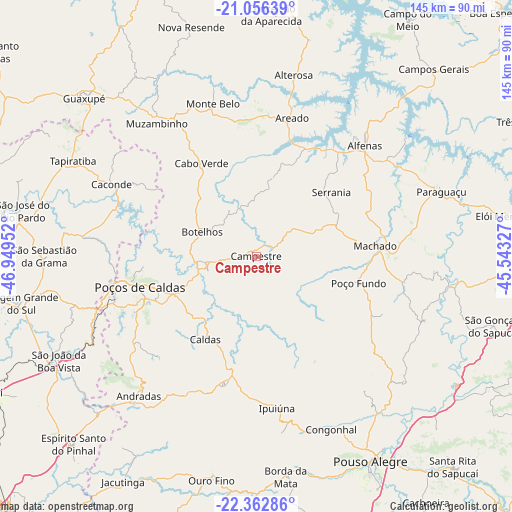
Campestre GPS coordinates[2]
21° 42' 39.996" South, 46° 14' 47.004" West
| Map corner | latitude | longitude |
|---|---|---|
| Upper-left | -21.05639°, | -46.94952° |
| Center: | -21.71111°, | -46.24639° |
| Lower-right: | -22.36286°, | -45.54327° |
| Map W x H: | 145.3×145.3 km | = 90.3×90.3mi |
| max Lat: | 2.81972° ⇑68% North |
| Campestre: | -21.71111° |
| min Lat: | ⇓32% South -33.69111° |
| min Long | Campestre | max Long |
| -72.89583° | -46.24639° | -32.41083° |
| W 46.6%⇐ | ⇒53.4% E |
Elevation
Elevation of Campestre is 1073 m = 3520 ft, and this is 692.1 m = 2271 ft above average elevation for this country.
| Max E: |
1603 m = 5259 ft | 0.7% |
| Campestre | 1073 m 3520 ft | |
| Avg. | 380.9 m = 1250 ft | |
Min E: |
0 m = 0 ft | 99.3% |
See also: Brazil elevation on elevation.city.
Geographical zone
Campestre is located in South Torrid zone (between Equator and Tropic of Capricorn). Distance of this Southern Tropic circle is 191.9 km =119.2 mi to South.| Distance of | km | miles | from Campestre |
|---|---|---|---|
| Equator | 2414 | 1500 | to North |
| Tropic Capricorn | 191.9 | 119.2 | to South |
| Antarctic Circle | 4987.1 | 3098.8 | to South |
| South Pole | 7593 | 4718.1 | to South |


Nearby cities:
15 places around Campestre: (largest is in red/bold)
• Alfenas
44 km =27.3 mi,  44°
44°
• Alterosa
52.5 km =32.6 mi,  11°
11°
• Andradas
51.8 km =32.2 mi,  219°
219°
• Areado
40.6 km =25.2 mi, 14°
• Borda da Mata
63.2 km =39.3 mi,  172°
172°
• Botelhos
17.6 km =10.9 mi,  299°
299°
• Caconde
45.8 km =28.5 mi, 296°
• Espírito Santo do Pinhal
63.7 km =39.6 mi,  225°
225°
• Guaxupé
66.1 km =41.1 mi,  313°
313°
• Machado
34 km =21.1 mi,  83°
83°
• Muzambinho
47.2 km =29.3 mi,  322°
322°
• Paraguaçu
55.7 km =34.6 mi,  70°
70°
• Pouso Alegre
66 km =41 mi,  151°
151°
• Poços de Caldas
33.6 km =20.9 mi,  255°
255°
• São João da Boa Vista
63.8 km =39.6 mi,  243°
243°
Sources, notices
• [Note1] Compared only with cities in Brazil existing in our database
• [Src1] Map data: © OpenStreetMap contributors (CC-BY-SA)
• [Src2] Other city data from geonames.org with taken over terms of usage.
• [Src3] Geographical zone / Annual Mean Temperature by Robert A. Rohde @ Wikipedia
