Panambi geodata
Panambi (Rio Grande do Sul) is a populated place; located in Brazil in America/Sao_Paulo (GMT-3) time zone. With population of 30,407 people, there are 663 cities with bigger population in this country. Compared to other cities in Brazil, 94.4% of cities are located further ↑North; 91.6% of cities are located further →East and 55.1% of cities have lower elevation than Panambi. Note1


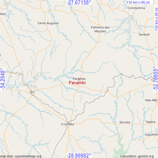
Panambi GPS coordinates[2]
28° 17' 33" South, 53° 30' 6.012" West
| Map corner | latitude | longitude |
|---|---|---|
| Upper-left | -27.67158°, | -54.2048° |
| Center: | -28.2925°, | -53.50167° |
| Lower-right: | -28.90982°, | -52.79855° |
| Map W x H: | 137.7×137.7 km | = 85.6×85.6mi |
| max Lat: | 2.81972° ⇑94.4% North |
| Panambi: | -28.2925° |
| min Lat: | ⇓5.6% South -33.69111° |
| min Long | Panambi | max Long |
| -72.89583° | -53.50167° | -32.41083° |
| W 8.4%⇐ | ⇒91.6% E |
Elevation
Elevation of Panambi is 421 m = 1381 ft, and this is 40.1 m = 132 ft above average elevation for this country.
| Max E: |
1603 m = 5259 ft | 44.9% |
| Panambi | 421 m 1381 ft | |
| Avg. | 380.9 m = 1250 ft | |
Min E: |
0 m = 0 ft | 55.1% |
See also: Brazil elevation on elevation.city.
Geographical zone
Panambi is located in South temperate zone (between Tropic of Capricorn and the Antarctic Circle). Distance of this Southern Tropic circle is 539.9 km =335.5 mi to North.| Distance of | km | miles | from Panambi |
|---|---|---|---|
| Equator | 3145.8 | 1954.7 | to North |
| Tropic Capricorn | 539.9 | 335.5 | to North |
| Antarctic Circle | 4255.3 | 2644.1 | to South |
| South Pole | 6861.2 | 4263.4 | to South |


Nearby cities:
15 places around Panambi: (largest is in red/bold)
• Carazinho
70 km =43.5 mi,  89°
89°
• Cruz Alta
40.4 km =25.1 mi,  194°
194°
• Espumoso
79.8 km =49.6 mi,  127°
127°
• Frederico Westphalen
104.3 km =64.8 mi,  5°
5°
• Giruá
88.2 km =54.8 mi,  289°
289°
• Ibirubá
54.9 km =34.1 mi, 132°
• Ijuí
41.8 km =26 mi,  255°
255°
• Não Me Toque
69.1 km =42.9 mi,  105°
105°
• Palmeira das Missões
47.4 km =29.5 mi,  22°
22°
• Santo Augusto
56.1 km =34.9 mi,  331°
331°
• Santo Ângelo
74.5 km =46.3 mi,  269°
269°
• Sarandi
68.7 km =42.7 mi,  55°
55°
• Três Passos
102.2 km =63.5 mi,  335°
335°
• Três de Maio
92.6 km =57.5 mi,  308°
308°
• Tupanciretã
93.5 km =58.1 mi,  200°
200°
Sources, notices
• [Note1] Compared only with cities in Brazil existing in our database
• [Src1] Map data: © OpenStreetMap contributors (CC-BY-SA)
• [Src2] Other city data from geonames.org with taken over terms of usage.
• [Src3] Geographical zone / Annual Mean Temperature by Robert A. Rohde @ Wikipedia
