Carazinho geodata
Carazinho (Rio Grande do Sul) is a populated place; located in Brazil in America/Sao_Paulo (GMT-3) time zone. With population of 59,417 people, there are 373 cities with bigger population in this country. Compared to other cities in Brazil, 94.4% of cities are located further ↑North; 89.9% of cities are located further →East and 73.3% of cities have lower elevation than Carazinho. Note1


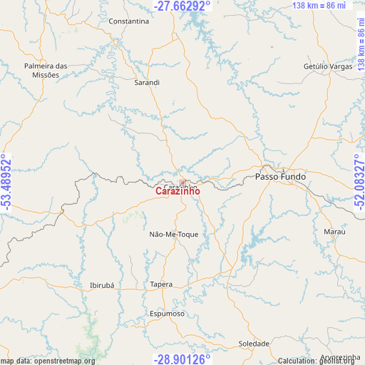
Carazinho GPS coordinates[2]
28° 17' 2.004" South, 52° 47' 11.004" West
| Map corner | latitude | longitude |
|---|---|---|
| Upper-left | -27.66292°, | -53.48952° |
| Center: | -28.28389°, | -52.78639° |
| Lower-right: | -28.90126°, | -52.08327° |
| Map W x H: | 137.7×137.7 km | = 85.6×85.6mi |
| max Lat: | 2.81972° ⇑94.4% North |
| Carazinho: | -28.28389° |
| min Lat: | ⇓5.6% South -33.69111° |
| min Long | Carazinho | max Long |
| -72.89583° | -52.78639° | -32.41083° |
| W 10.1%⇐ | ⇒89.9% E |
Elevation
Elevation of Carazinho is 605 m = 1985 ft, and this is 224.1 m = 735 ft above average elevation for this country.
| Max E: |
1603 m = 5259 ft | 26.7% |
| Carazinho | 605 m 1985 ft | |
| Avg. | 380.9 m = 1250 ft | |
Min E: |
0 m = 0 ft | 73.3% |
See also: Carazinho elevation on elevation.city.
Geographical zone
Carazinho is located in South temperate zone (between Tropic of Capricorn and the Antarctic Circle). Distance of this Southern Tropic circle is 539 km =334.9 mi to North.| Distance of | km | miles | from Carazinho |
|---|---|---|---|
| Equator | 3144.9 | 1954.1 | to North |
| Tropic Capricorn | 539 | 334.9 | to North |
| Antarctic Circle | 4256.3 | 2644.7 | to South |
| South Pole | 6862.2 | 4264 | to South |


Nearby cities:
15 places around Carazinho: (largest is in red/bold)
• Cruz Alta
89.6 km =55.7 mi,  243°
243°
• Erechim
87.9 km =54.6 mi,  34°
34°
• Espumoso
49.4 km =30.7 mi,  187°
187°
• Guaporé
107.5 km =66.8 mi,  125°
125°
• Ibirubá
48.4 km =30.1 mi,  217°
217°
• Marau
60.2 km =37.4 mi,  107°
107°
• Não Me Toque
19.8 km =12.3 mi, 189°
• Palmeira das Missões
67.1 km =41.7 mi,  309°
309°
• Panambi
70 km =43.5 mi,  269°
269°
• Passo Fundo
37.3 km =23.2 mi,  86°
86°
• Sananduva
103 km =64 mi,  68°
68°
• Santo Augusto
108.5 km =67.4 mi,  296°
296°
• Sarandi
40.1 km =24.9 mi,  340°
340°
• Soledade
65.3 km =40.6 mi,  155°
155°
• Tapejara
79.4 km =49.3 mi, 72°
Sources, notices
• [Note1] Compared only with cities in Brazil existing in our database
• [Src1] Map data: © OpenStreetMap contributors (CC-BY-SA)
• [Src2] Other city data from geonames.org with taken over terms of usage.
• [Src3] Geographical zone / Annual Mean Temperature by Robert A. Rohde @ Wikipedia
