Ijuí geodata
Ijuí (Rio Grande do Sul) is a populated place; located in Brazil in America/Sao_Paulo (GMT-3) time zone. With population of 71,202 people, there are 321 cities with bigger population in this country. Compared to other cities in Brazil, 94.6% of cities are located further ↑North; 92.4% of cities are located further →East and 51.7% of cities have higher elevation than Ijuí. Note1


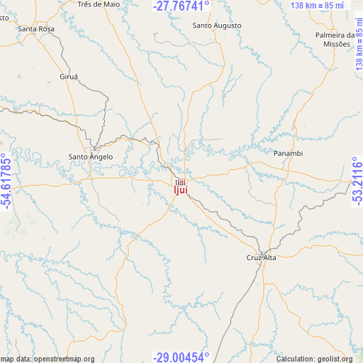
Ijuí GPS coordinates[2]
28° 23' 16.008" South, 53° 54' 52.992" West
| Map corner | latitude | longitude |
|---|---|---|
| Upper-left | -27.76741°, | -54.61785° |
| Center: | -28.38778°, | -53.91472° |
| Lower-right: | -29.00454°, | -53.2116° |
| Map W x H: | 137.6×137.6 km | = 85.5×85.5mi |
| max Lat: | 2.81972° ⇑94.6% North |
| Ijuí: | -28.38778° |
| min Lat: | ⇓5.4% South -33.69111° |
| min Long | Ijuí | max Long |
| -72.89583° | -53.91472° | -32.41083° |
| W 7.6%⇐ | ⇒92.4% E |
Elevation
Elevation of Ijuí is 329 m = 1079 ft, and this is 51.9 m = 170 ft below average elevation for this country.
| Max E: |
1603 m = 5259 ft | 51.7% |
| Avg. | 380.9 m = 1250 ft | |
| Ijuí | 329 m = 1079 ft | |
Min E: |
0 m = 0 ft | 48.3% |
See also: Ijuí elevation on elevation.city.
Geographical zone
Ijuí is located in South temperate zone (between Tropic of Capricorn and the Antarctic Circle). Distance of this Southern Tropic circle is 550.5 km =342.1 mi to North.| Distance of | km | miles | from Ijuí |
|---|---|---|---|
| Equator | 3156.4 | 1961.3 | to North |
| Tropic Capricorn | 550.5 | 342.1 | to North |
| Antarctic Circle | 4244.7 | 2637.5 | to South |
| South Pole | 6850.6 | 4256.8 | to South |


Nearby cities:
15 places around Ijuí: (largest is in red/bold)
• Butia Inferior
101.4 km =63 mi,  290°
290°
• Cerro Largo
84.9 km =52.8 mi, 288°
• Cruz Alta
41.5 km =25.8 mi,  133°
133°
• Giruá
58.4 km =36.3 mi,  313°
313°
• Horizontina
93.1 km =57.8 mi,  335°
335°
• Ibirubá
84.9 km =52.8 mi,  108°
108°
• Júlio de Castilhos
96 km =59.7 mi,  166°
166°
• Palmeira das Missões
80.1 km =49.8 mi,  47°
47°
• Panambi
41.8 km =26 mi,  75°
75°
• Santa Rosa
79.9 km =49.6 mi,  315°
315°
• Santo Augusto
61.2 km =38 mi,  12°
12°
• Santo Ângelo
35.5 km =22.1 mi, 286°
• São Luiz Gonzaga
102.3 km =63.6 mi,  268°
268°
• Três de Maio
75.4 km =46.9 mi,  334°
334°
• Tupanciretã
77.4 km =48.1 mi, 174°
Sources, notices
• [Note1] Compared only with cities in Brazil existing in our database
• [Src1] Map data: © OpenStreetMap contributors (CC-BY-SA)
• [Src2] Other city data from geonames.org with taken over terms of usage.
• [Src3] Geographical zone / Annual Mean Temperature by Robert A. Rohde @ Wikipedia
