Santo Augusto geodata
Santo Augusto (Rio Grande do Sul) is a populated place; located in Brazil in America/Sao_Paulo (GMT-3) time zone. With population of 10,305 people, there are 1622 cities with bigger population in this country. Compared to other cities in Brazil, 93.6% of cities are located further ↑North; 92.1% of cities are located further →East and 66.1% of cities have lower elevation than Santo Augusto. Note1


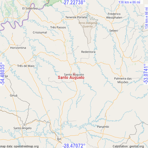
Santo Augusto GPS coordinates[2]
27° 51' 2.988" South, 53° 46' 37.992" West
| Map corner | latitude | longitude |
|---|---|---|
| Upper-left | -27.22738°, | -54.48035° |
| Center: | -27.85083°, | -53.77722° |
| Lower-right: | -28.47072°, | -53.0741° |
| Map W x H: | 138.2×138.2 km | = 85.9×85.9mi |
| max Lat: | 2.81972° ⇑93.6% North |
| Santo Augusto: | -27.85083° |
| min Lat: | ⇓6.4% South -33.69111° |
| min Long | Santo Augusto | max Long |
| -72.89583° | -53.77722° | -32.41083° |
| W 7.9%⇐ | ⇒92.1% E |
Elevation
Elevation of Santo Augusto is 533 m = 1749 ft, and this is 152.1 m = 499 ft above average elevation for this country.
| Max E: |
1603 m = 5259 ft | 33.9% |
| Santo Augusto | 533 m 1749 ft | |
| Avg. | 380.9 m = 1250 ft | |
Min E: |
0 m = 0 ft | 66.1% |
See also: Brazil elevation on elevation.city.
Geographical zone
Santo Augusto is located in South temperate zone (between Tropic of Capricorn and the Antarctic Circle). Distance of this Southern Tropic circle is 490.8 km =305 mi to North.| Distance of | km | miles | from Santo Augusto |
|---|---|---|---|
| Equator | 3096.7 | 1924.2 | to North |
| Tropic Capricorn | 490.8 | 305 | to North |
| Antarctic Circle | 4304.5 | 2674.7 | to South |
| South Pole | 6910.3 | 4293.9 | to South |


Nearby cities:
15 places around Santo Augusto: (largest is in red/bold)
• Carazinho
108.5 km =67.4 mi,  116°
116°
• Cerro Largo
100 km =62.1 mi,  250°
250°
• Cruz Alta
89.8 km =55.8 mi,  169°
169°
• Frederico Westphalen
66.4 km =41.3 mi,  34°
34°
• Giruá
59.6 km =37 mi, 250°
• Horizontina
57.9 km =36 mi,  295°
295°
• Ibirubá
109.5 km =68 mi,  142°
142°
• Ijuí
61.2 km =38 mi,  192°
192°
• Palmeira das Missões
45.9 km =28.5 mi,  96°
96°
• Panambi
56.1 km =34.9 mi,  151°
151°
• Santa Rosa
69.3 km =43.1 mi,  268°
268°
• Santo Ângelo
69 km =42.9 mi,  223°
223°
• Sarandi
84.6 km =52.6 mi, 97°
• Três Passos
46.5 km =28.9 mi,  340°
340°
• Três de Maio
46.3 km =28.8 mi,  280°
280°
Sources, notices
• [Note1] Compared only with cities in Brazil existing in our database
• [Src1] Map data: © OpenStreetMap contributors (CC-BY-SA)
• [Src2] Other city data from geonames.org with taken over terms of usage.
• [Src3] Geographical zone / Annual Mean Temperature by Robert A. Rohde @ Wikipedia
