Apucarana geodata
Apucarana (Paraná) is a populated place; located in Brazil in America/Sao_Paulo (GMT-3) time zone. With population of 107,085 people, there are 215 cities with bigger population in this country. Compared to other cities in Brazil, 83.4% of cities are located further ↑North; 85.2% of cities are located further →East and 93.3% of cities have lower elevation than Apucarana. Note1


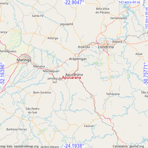
Apucarana GPS coordinates[2]
23° 33' 2.988" South, 51° 27' 38.988" West
| Map corner | latitude | longitude |
|---|---|---|
| Upper-left | -22.9047°, | -52.16396° |
| Center: | -23.55083°, | -51.46083° |
| Lower-right: | -24.1938°, | -50.75771° |
| Map W x H: | 143.3×143.3 km | = 89×89mi |
| max Lat: | 2.81972° ⇑83.4% North |
| Apucarana: | -23.55083° |
| min Lat: | ⇓16.6% South -33.69111° |
| min Long | Apucarana | max Long |
| -72.89583° | -51.46083° | -32.41083° |
| W 14.8%⇐ | ⇒85.2% E |
Elevation
Elevation of Apucarana is 871 m = 2858 ft, and this is 490.1 m = 1608 ft above average elevation for this country.
| Max E: |
1603 m = 5259 ft | 6.7% |
| Apucarana | 871 m 2858 ft | |
| Avg. | 380.9 m = 1250 ft | |
Min E: |
0 m = 0 ft | 93.3% |
See also: Apucarana elevation on elevation.city.
Geographical zone
Apucarana is located in South temperate zone (between Tropic of Capricorn and the Antarctic Circle). Distance of this Southern Tropic circle is 12.7 km =7.9 mi to North.| Distance of | km | miles | from Apucarana |
|---|---|---|---|
| Equator | 2618.6 | 1627.1 | to North |
| Tropic Capricorn | 12.7 | 7.9 | to North |
| Antarctic Circle | 4782.6 | 2971.8 | to South |
| South Pole | 7388.5 | 4591 | to South |


Nearby cities:
15 places around Apucarana: (largest is in red/bold)
• Arapongas
15.1 km =9.4 mi,  14°
14°
• Assaí
66.2 km =41.1 mi,  72°
72°
• Astorga
41.1 km =25.5 mi,  329°
329°
• Cambé
35.8 km =22.2 mi,  31°
31°
• Faxinal
52 km =32.3 mi,  163°
163°
• Ibiporã
52.5 km =32.6 mi,  53°
53°
• Jandaia do Sul
19.5 km =12.1 mi,  252°
252°
• Jataizinho
59.1 km =36.7 mi,  56°
56°
• Londrina
40.5 km =25.2 mi, 48°
• Mandaguari
21.4 km =13.3 mi,  270°
270°
• Marialva
34.5 km =21.4 mi,  282°
282°
• Maringá
50.7 km =31.5 mi,  285°
285°
• Paiçandu
60.8 km =37.8 mi, 279°
• Rolândia
28.4 km =17.6 mi,  19°
19°
• Sarandi
43.8 km =27.2 mi, 285°
Sources, notices
• [Note1] Compared only with cities in Brazil existing in our database
• [Src1] Map data: © OpenStreetMap contributors (CC-BY-SA)
• [Src2] Other city data from geonames.org with taken over terms of usage.
• [Src3] Geographical zone / Annual Mean Temperature by Robert A. Rohde @ Wikipedia
