Astorga geodata
Astorga (Paraná) is a populated place; located in Brazil in America/Sao_Paulo (GMT-3) time zone. With population of 20,128 people, there are 932 cities with bigger population in this country. Compared to other cities in Brazil, 80.6% of cities are located further ↑North; 86.3% of cities are located further →East and 79.9% of cities have lower elevation than Astorga. Note1


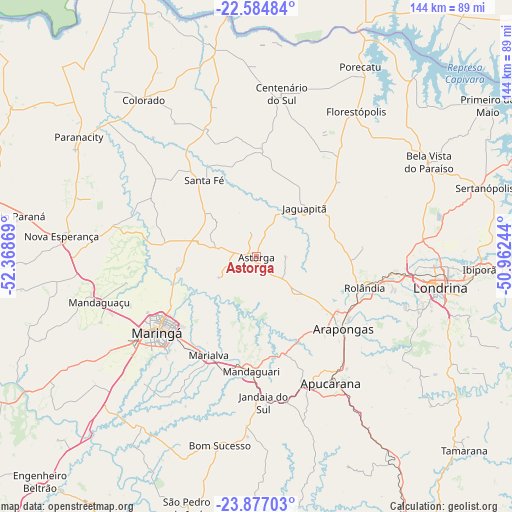
Astorga GPS coordinates[2]
23° 13' 57" South, 51° 39' 56.016" West
| Map corner | latitude | longitude |
|---|---|---|
| Upper-left | -22.58484°, | -52.36869° |
| Center: | -23.2325°, | -51.66556° |
| Lower-right: | -23.87703°, | -50.96244° |
| Map W x H: | 143.7×143.7 km | = 89.3×89.3mi |
| max Lat: | 2.81972° ⇑80.6% North |
| Astorga: | -23.2325° |
| min Lat: | ⇓19.4% South -33.69111° |
| min Long | Astorga | max Long |
| -72.89583° | -51.66556° | -32.41083° |
| W 13.7%⇐ | ⇒86.3% E |
Elevation
Elevation of Astorga is 688 m = 2257 ft, and this is 307.1 m = 1008 ft above average elevation for this country.
| Max E: |
1603 m = 5259 ft | 20.1% |
| Astorga | 688 m 2257 ft | |
| Avg. | 380.9 m = 1250 ft | |
Min E: |
0 m = 0 ft | 79.9% |
See also: Brazil elevation on elevation.city.
Geographical zone
Astorga is located in South Torrid zone (between Equator and Tropic of Capricorn). Distance of this Southern Tropic circle is 22.7 km =14.1 mi to South.| Distance of | km | miles | from Astorga |
|---|---|---|---|
| Equator | 2583.2 | 1605.1 | to North |
| Tropic Capricorn | 22.7 | 14.1 | to South |
| Antarctic Circle | 4818 | 2993.8 | to South |
| South Pole | 7423.9 | 4613 | to South |


Nearby cities:
15 places around Astorga: (largest is in red/bold)
• Apucarana
41.1 km =25.5 mi,  149°
149°
• Arapongas
32.2 km =20 mi,  130°
130°
• Cambé
39.9 km =24.8 mi,  96°
96°
• Centenário do Sul
46.3 km =28.8 mi,  8°
8°
• Colorado
54 km =33.6 mi,  324°
324°
• Florestópolis
50 km =31.1 mi,  34°
34°
• Jandaia do Sul
41.3 km =25.7 mi,  176°
176°
• Londrina
52.1 km =32.4 mi, 99°
• Mandaguari
35 km =21.7 mi, 180°
• Mandaguaçu
45.7 km =28.4 mi,  253°
253°
• Marialva
30.9 km =19.2 mi,  204°
204°
• Maringá
35.2 km =21.9 mi,  232°
232°
• Paiçandu
46.4 km =28.8 mi,  237°
237°
• Rolândia
31.5 km =19.6 mi,  105°
105°
• Sarandi
31.7 km =19.7 mi,  222°
222°
Sources, notices
• [Note1] Compared only with cities in Brazil existing in our database
• [Src1] Map data: © OpenStreetMap contributors (CC-BY-SA)
• [Src2] Other city data from geonames.org with taken over terms of usage.
• [Src3] Geographical zone / Annual Mean Temperature by Robert A. Rohde @ Wikipedia
