Promissão geodata
Promissão (São Paulo) is a populated place; located in Brazil in America/Sao_Paulo (GMT-3) time zone. With population of 27,031 people, there are 731 cities with bigger population in this country. Compared to other cities in Brazil, 66.8% of cities are located further ↑North; 77.5% of cities are located further →East and 55.8% of cities have lower elevation than Promissão. Note1


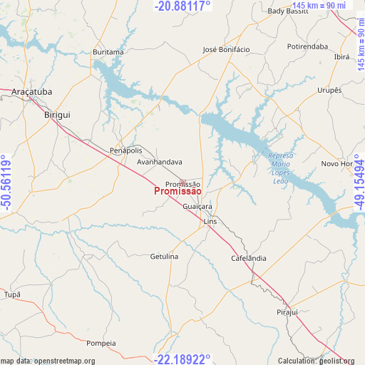
Promissão GPS coordinates[2]
21° 32' 12.012" South, 49° 51' 29.016" West
| Map corner | latitude | longitude |
|---|---|---|
| Upper-left | -20.88117°, | -50.56119° |
| Center: | -21.53667°, | -49.85806° |
| Lower-right: | -22.18922°, | -49.15494° |
| Map W x H: | 145.4×145.4 km | = 90.3×90.3mi |
| max Lat: | 2.81972° ⇑66.8% North |
| Promissão: | -21.53667° |
| min Lat: | ⇓33.2% South -33.69111° |
| min Long | Promissão | max Long |
| -72.89583° | -49.85806° | -32.41083° |
| W 22.5%⇐ | ⇒77.5% E |
Elevation
Elevation of Promissão is 428 m = 1404 ft, and this is 47.1 m = 155 ft above average elevation for this country.
| Max E: |
1603 m = 5259 ft | 44.2% |
| Promissão | 428 m 1404 ft | |
| Avg. | 380.9 m = 1250 ft | |
Min E: |
0 m = 0 ft | 55.8% |
See also: Brazil elevation on elevation.city.
Geographical zone
Promissão is located in South Torrid zone (between Equator and Tropic of Capricorn). Distance of this Southern Tropic circle is 211.3 km =131.3 mi to South.| Distance of | km | miles | from Promissão |
|---|---|---|---|
| Equator | 2394.7 | 1488 | to North |
| Tropic Capricorn | 211.3 | 131.3 | to South |
| Antarctic Circle | 5006.5 | 3110.9 | to South |
| South Pole | 7612.4 | 4730.1 | to South |


Nearby cities:
15 places around Promissão: (largest is in red/bold)
• Araçatuba
69.8 km =43.4 mi,  301°
301°
• Bady Bassitt
81 km =50.3 mi,  31°
31°
• Birigui
57 km =35.4 mi, 298°
• Buritama
60.3 km =37.5 mi,  330°
330°
• Cafelândia
39.1 km =24.3 mi,  139°
139°
• Garça
77.8 km =48.3 mi,  164°
164°
• José Bonifácio
56.6 km =35.2 mi,  18°
18°
• Lins
19.8 km =12.3 mi, 142°
• Marília
75.8 km =47.1 mi,  186°
186°
• Novo Horizonte
66.4 km =41.3 mi,  83°
83°
• Penápolis
26.2 km =16.3 mi, 299°
• Pirajuí
66 km =41 mi, 141°
• Pompéia
71.4 km =44.4 mi,  206°
206°
• Tupã
80.9 km =50.3 mi,  236°
236°
• Urupês
69.6 km =43.2 mi,  57°
57°
Sources, notices
• [Note1] Compared only with cities in Brazil existing in our database
• [Src1] Map data: © OpenStreetMap contributors (CC-BY-SA)
• [Src2] Other city data from geonames.org with taken over terms of usage.
• [Src3] Geographical zone / Annual Mean Temperature by Robert A. Rohde @ Wikipedia
