Centenário do Sul geodata
Centenário do Sul (Paraná) is a populated place; located in Brazil in America/Sao_Paulo (GMT-3) time zone. With population of 8,357 people, there are 1757 cities with bigger population in this country. Compared to other cities in Brazil, 76.8% of cities are located further ↑North; 85.9% of cities are located further →East and 61.5% of cities have lower elevation than Centenário do Sul. Note1


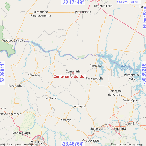
Centenário do Sul GPS coordinates[2]
22° 49' 15.996" South, 51° 35' 43.008" West
| Map corner | latitude | longitude |
|---|---|---|
| Upper-left | -22.17149°, | -52.29841° |
| Center: | -22.82111°, | -51.59528° |
| Lower-right: | -23.46764°, | -50.89216° |
| Map W x H: | 144.1×144.1 km | = 89.5×89.5mi |
| max Lat: | 2.81972° ⇑76.8% North |
| Centenário do Sul: | -22.82111° |
| min Lat: | ⇓23.2% South -33.69111° |
| min Long | Centenário do | max Long |
| -72.89583° | -51.59528° | -32.41083° |
| W 14.1%⇐ | ⇒85.9% E |
Elevation
Elevation of Centenário do Sul is 491 m = 1611 ft, and this is 110.1 m = 361 ft above average elevation for this country.
| Max E: |
1603 m = 5259 ft | 38.5% |
| Centenário do Sul | 491 m 1611 ft | |
| Avg. | 380.9 m = 1250 ft | |
Min E: |
0 m = 0 ft | 61.5% |
See also: Brazil elevation on elevation.city.
Geographical zone
Centenário do Sul is located in South Torrid zone (between Equator and Tropic of Capricorn). Distance of this Southern Tropic circle is 68.4 km =42.5 mi to South.| Distance of | km | miles | from Centenário do Sul |
|---|---|---|---|
| Equator | 2537.5 | 1576.7 | to North |
| Tropic Capricorn | 68.4 | 42.5 | to South |
| Antarctic Circle | 4863.7 | 3022.2 | to South |
| South Pole | 7469.6 | 4641.4 | to South |


Nearby cities:
15 places around Centenário do Sul: (largest is in red/bold)
• Arapongas
68.8 km =42.8 mi,  165°
165°
• Astorga
46.3 km =28.8 mi,  188°
188°
• Bela Vista do Paraíso
45.8 km =28.5 mi,  115°
115°
• Cambé
60.1 km =37.3 mi,  147°
147°
• Colorado
38.8 km =24.1 mi,  267°
267°
• Florestópolis
21.8 km =13.5 mi,  102°
102°
• Londrina
70.1 km =43.6 mi,  140°
140°
• Mirante do Paranapanema
67 km =41.6 mi,  331°
331°
• Pirapozinho
61.5 km =38.2 mi,  9°
9°
• Porecatu
23.3 km =14.5 mi,  71°
71°
• Regente Feijó
73.1 km =45.4 mi,  24°
24°
• Rolândia
59 km =36.7 mi,  156°
156°
• Sarandi
74.8 km =46.5 mi,  202°
202°
• Sertanópolis
63 km =39.1 mi,  114°
114°
• Teodoro Sampaio
66.9 km =41.6 mi,  298°
298°
Sources, notices
• [Note1] Compared only with cities in Brazil existing in our database
• [Src1] Map data: © OpenStreetMap contributors (CC-BY-SA)
• [Src2] Other city data from geonames.org with taken over terms of usage.
• [Src3] Geographical zone / Annual Mean Temperature by Robert A. Rohde @ Wikipedia
