Lavras geodata
Lavras (Minas Gerais) is a populated place; located in Brazil in America/Sao_Paulo (GMT-3) time zone. With population of 81,472 people, there are 282 cities with bigger population in this country. Compared to other cities in Brazil, 65% of cities are located further ↑North; 51.2% of cities are located further ←West and 96.3% of cities have lower elevation than Lavras. Note1


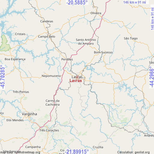
Lavras GPS coordinates[2]
21° 14' 43.008" South, 44° 59' 58.992" West
| Map corner | latitude | longitude |
|---|---|---|
| Upper-left | -20.5885°, | -45.70285° |
| Center: | -21.24528°, | -44.99972° |
| Lower-right: | -21.89915°, | -44.2966° |
| Map W x H: | 145.7×145.7 km | = 90.5×90.5mi |
| max Lat: | 2.81972° ⇑65% North |
| Lavras: | -21.24528° |
| min Lat: | ⇓35% South -33.69111° |
| min Long | Lavras | max Long |
| -72.89583° | -44.99972° | -32.41083° |
| W 51.2%⇐ | ⇒48.8% E |
Elevation
Elevation of Lavras is 924 m = 3031 ft, and this is 543.1 m = 1782 ft above average elevation for this country.
| Max E: |
1603 m = 5259 ft | 3.7% |
| Lavras | 924 m 3031 ft | |
| Avg. | 380.9 m = 1250 ft | |
Min E: |
0 m = 0 ft | 96.3% |
See also: Lavras elevation on elevation.city.
Geographical zone
Lavras is located in South Torrid zone (between Equator and Tropic of Capricorn). Distance of this Southern Tropic circle is 243.7 km =151.4 mi to South.| Distance of | km | miles | from Lavras |
|---|---|---|---|
| Equator | 2362.3 | 1467.9 | to North |
| Tropic Capricorn | 243.7 | 151.4 | to South |
| Antarctic Circle | 5038.9 | 3131 | to South |
| South Pole | 7644.8 | 4750.3 | to South |


Nearby cities:
15 places around Lavras: (largest is in red/bold)
• Boa Esperança
61.2 km =38 mi,  286°
286°
• Bom Sucesso
34.4 km =21.4 mi,  46°
46°
• Cambuquira
74.1 km =46 mi,  204°
204°
• Campo Belo
48.2 km =30 mi,  323°
323°
• Conceição do Rio Verde
71.2 km =44.2 mi,  187°
187°
• Cruzília
68.9 km =42.8 mi,  163°
163°
• Elói Mendes
71.2 km =44.2 mi,  235°
235°
• Nepomuceno
24.4 km =15.2 mi,  273°
273°
• Oliveira
63.6 km =39.5 mi,  16°
16°
• Perdões
19.6 km =12.2 mi,  331°
331°
• Santo Antônio do Amparo
34.3 km =21.3 mi,  14°
14°
• São João del Rei
77.5 km =48.2 mi,  80°
80°
• Três Corações
56.7 km =35.2 mi,  207°
207°
• Três Pontas
54.8 km =34.1 mi,  255°
255°
• Varginha
56.1 km =34.9 mi,  232°
232°
Sources, notices
• [Note1] Compared only with cities in Brazil existing in our database
• [Src1] Map data: © OpenStreetMap contributors (CC-BY-SA)
• [Src2] Other city data from geonames.org with taken over terms of usage.
• [Src3] Geographical zone / Annual Mean Temperature by Robert A. Rohde @ Wikipedia
