São João del Rei geodata
São João del Rei (Minas Gerais) is a populated place; located in Brazil in America/Sao_Paulo (GMT-3) time zone. With population of 78,592 people, there are 291 cities with bigger population in this country. Compared to other cities in Brazil, 64% of cities are located further ↑North; 54.4% of cities are located further ←West and 95.8% of cities have lower elevation than São João del Rei. Note1


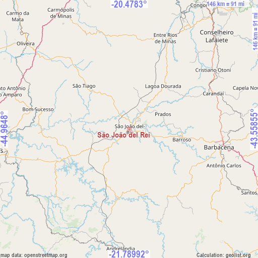
São João del Rei GPS coordinates[2]
21° 8' 8.016" South, 44° 15' 42.012" West
| Map corner | latitude | longitude |
|---|---|---|
| Upper-left | -20.4783°, | -44.9648° |
| Center: | -21.13556°, | -44.26167° |
| Lower-right: | -21.78992°, | -43.55855° |
| Map W x H: | 145.8×145.8 km | = 90.6×90.6mi |
| max Lat: | 2.81972° ⇑64% North |
| São João del Rei: | -21.13556° |
| min Lat: | ⇓36% South -33.69111° |
| min Long | São João del | max Long |
| -72.89583° | -44.26167° | -32.41083° |
| W 54.4%⇐ | ⇒45.6% E |
Elevation
Elevation of São João del Rei is 911 m = 2989 ft, and this is 530.1 m = 1739 ft above average elevation for this country.
| Max E: |
1603 m = 5259 ft | 4.2% |
| São João del Rei | 911 m 2989 ft | |
| Avg. | 380.9 m = 1250 ft | |
Min E: |
0 m = 0 ft | 95.8% |
See also: São João del Rei elevation on elevation.city.
Geographical zone
São João del Rei is located in South Torrid zone (between Equator and Tropic of Capricorn). Distance of this Southern Tropic circle is 255.9 km =159 mi to South.| Distance of | km | miles | from São João del Rei |
|---|---|---|---|
| Equator | 2350.1 | 1460.3 | to North |
| Tropic Capricorn | 255.9 | 159 | to South |
| Antarctic Circle | 5051.1 | 3138.6 | to South |
| South Pole | 7657 | 4757.8 | to South |


Nearby cities:
15 places around São João del Rei: (largest is in red/bold)
• Andrelândia
67.4 km =41.9 mi,  184°
184°
• Barbacena
51.6 km =32.1 mi,  101°
101°
• Barroso
30.2 km =18.8 mi, 100°
• Bom Sucesso
52.7 km =32.7 mi,  282°
282°
• Carandaí
51.4 km =31.9 mi,  66°
66°
• Congonhas
81.6 km =50.7 mi,  30°
30°
• Conselheiro Lafaiete
72.3 km =44.9 mi,  43°
43°
• Lavras
77.5 km =48.2 mi,  260°
260°
• Lima Duarte
92.4 km =57.4 mi,  148°
148°
• Oliveira
76.4 km =47.5 mi,  309°
309°
• Ouro Branco
90 km =55.9 mi, 40°
• Perdões
86.2 km =53.6 mi,  273°
273°
• Santo Antônio do Amparo
71.4 km =44.4 mi,  287°
287°
• Santos Dumont
81.7 km =50.8 mi,  115°
115°
• Tiradentes
9.1 km =5.7 mi, 72°
In other languages:
- In Spanish: São João del-Rei
- In France: São João del-Rei
- In Italian: São João del-Rei
- In Russian: Сан-Жуан-дел-Рей
- In Chinese: 圣若昂-德雷
Sources, notices
• [Note1] Compared only with cities in Brazil existing in our database
• [Src1] Map data: © OpenStreetMap contributors (CC-BY-SA)
• [Src2] Other city data from geonames.org with taken over terms of usage.
• [Src3] Geographical zone / Annual Mean Temperature by Robert A. Rohde @ Wikipedia
