Jataizinho geodata
Jataizinho (Paraná) is a populated place; located in Brazil in America/Sao_Paulo (GMT-3) time zone. With population of 10,014 people, there are 1651 cities with bigger population in this country. Compared to other cities in Brazil, 80.7% of cities are located further ↑North; 82.3% of cities are located further →East and 50.2% of cities have lower elevation than Jataizinho. Note1


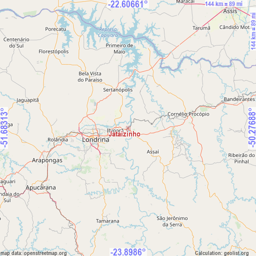
Jataizinho GPS coordinates[2]
23° 15' 15.012" South, 50° 58' 48" West
| Map corner | latitude | longitude |
|---|---|---|
| Upper-left | -22.60661°, | -51.68313° |
| Center: | -23.25417°, | -50.98° |
| Lower-right: | -23.8986°, | -50.27688° |
| Map W x H: | 143.7×143.7 km | = 89.3×89.3mi |
| max Lat: | 2.81972° ⇑80.7% North |
| Jataizinho: | -23.25417° |
| min Lat: | ⇓19.3% South -33.69111° |
| min Long | Jataizinho | max Long |
| -72.89583° | -50.98° | -32.41083° |
| W 17.7%⇐ | ⇒82.3% E |
Elevation
Elevation of Jataizinho is 355 m = 1165 ft, and this is 25.9 m = 85 ft below average elevation for this country.
| Max E: |
1603 m = 5259 ft | 49.8% |
| Avg. | 380.9 m = 1250 ft | |
| Jataizinho | 355 m = 1165 ft | |
Min E: |
0 m = 0 ft | 50.2% |
See also: Brazil elevation on elevation.city.
Geographical zone
Jataizinho is located in South Torrid zone (between Equator and Tropic of Capricorn). Distance of this Southern Tropic circle is 20.3 km =12.6 mi to South.| Distance of | km | miles | from Jataizinho |
|---|---|---|---|
| Equator | 2585.6 | 1606.6 | to North |
| Tropic Capricorn | 20.3 | 12.6 | to South |
| Antarctic Circle | 4815.6 | 2992.3 | to South |
| South Pole | 7421.4 | 4611.4 | to South |


Nearby cities:
15 places around Jataizinho: (largest is in red/bold)
• Apucarana
59.1 km =36.7 mi,  236°
236°
• Arapongas
49 km =30.4 mi,  247°
247°
• Assaí
19.4 km =12.1 mi,  133°
133°
• Astorga
70.1 km =43.6 mi,  271°
271°
• Bandeirantes
64.6 km =40.1 mi,  75°
75°
• Bela Vista do Paraíso
35.8 km =22.2 mi,  323°
323°
• Cambé
30.6 km =19 mi, 265°
• Cornélio Procópio
35 km =21.7 mi, 76°
• Florestópolis
60.2 km =37.4 mi, 316°
• Ibiporã
7.1 km =4.4 mi,  256°
256°
• Londrina
19.7 km =12.2 mi, 251°
• Porecatu
68.8 km =42.8 mi, 323°
• Rolândia
40.2 km =25 mi, 261°
• Sertanópolis
22.5 km =14 mi,  345°
345°
• Tarumã
69.9 km =43.4 mi,  36°
36°
Sources, notices
• [Note1] Compared only with cities in Brazil existing in our database
• [Src1] Map data: © OpenStreetMap contributors (CC-BY-SA)
• [Src2] Other city data from geonames.org with taken over terms of usage.
• [Src3] Geographical zone / Annual Mean Temperature by Robert A. Rohde @ Wikipedia
