Ibiporã geodata
Ibiporã (Paraná) is a populated place; located in Brazil in America/Sao_Paulo (GMT-3) time zone. With population of 44,790 people, there are 477 cities with bigger population in this country. Compared to other cities in Brazil, 80.8% of cities are located further ↑North; 82.6% of cities are located further →East and 62.3% of cities have lower elevation than Ibiporã. Note1


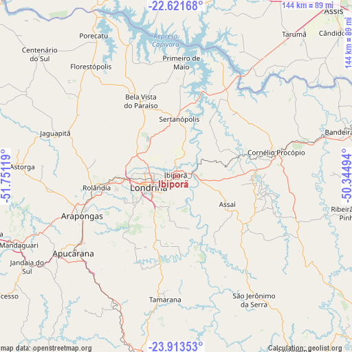
Ibiporã GPS coordinates[2]
23° 16' 9.012" South, 51° 2' 53.016" West
| Map corner | latitude | longitude |
|---|---|---|
| Upper-left | -22.62168°, | -51.75119° |
| Center: | -23.26917°, | -51.04806° |
| Lower-right: | -23.91353°, | -50.34494° |
| Map W x H: | 143.6×143.6 km | = 89.2×89.2mi |
| max Lat: | 2.81972° ⇑80.8% North |
| Ibiporã: | -23.26917° |
| min Lat: | ⇓19.2% South -33.69111° |
| min Long | Ibiporã | max Long |
| -72.89583° | -51.04806° | -32.41083° |
| W 17.4%⇐ | ⇒82.6% E |
Elevation
Elevation of Ibiporã is 500 m = 1640 ft, and this is 119.1 m = 391 ft above average elevation for this country.
| Max E: |
1603 m = 5259 ft | 37.7% |
| Ibiporã | 500 m 1640 ft | |
| Avg. | 380.9 m = 1250 ft | |
Min E: |
0 m = 0 ft | 62.3% |
See also: Ibiporã elevation on elevation.city.
Geographical zone
Ibiporã is located in South Torrid zone (between Equator and Tropic of Capricorn). Distance of this Southern Tropic circle is 18.6 km =11.6 mi to South.| Distance of | km | miles | from Ibiporã |
|---|---|---|---|
| Equator | 2587.3 | 1607.7 | to North |
| Tropic Capricorn | 18.6 | 11.6 | to South |
| Antarctic Circle | 4813.9 | 2991.2 | to South |
| South Pole | 7419.8 | 4610.4 | to South |


Nearby cities:
15 places around Ibiporã: (largest is in red/bold)
• Apucarana
52.5 km =32.6 mi,  233°
233°
• Arapongas
41.9 km =26 mi,  246°
246°
• Assaí
24.1 km =15 mi,  118°
118°
• Astorga
63.2 km =39.3 mi,  273°
273°
• Bela Vista do Paraíso
33.6 km =20.9 mi,  334°
334°
• Cambé
23.5 km =14.6 mi, 268°
• Cornélio Procópio
42.2 km =26.2 mi,  76°
76°
• Florestópolis
56.9 km =35.4 mi,  322°
322°
• Jandaia do Sul
71.2 km =44.2 mi,  238°
238°
• Jataizinho
7.1 km =4.4 mi, 76°
• Londrina
12.6 km =7.8 mi, 248°
• Mandaguari
70.7 km =43.9 mi, 244°
• Porecatu
66.4 km =41.3 mi, 329°
• Rolândia
33.1 km =20.6 mi,  262°
262°
• Sertanópolis
23.4 km =14.5 mi,  2°
2°
Sources, notices
• [Note1] Compared only with cities in Brazil existing in our database
• [Src1] Map data: © OpenStreetMap contributors (CC-BY-SA)
• [Src2] Other city data from geonames.org with taken over terms of usage.
• [Src3] Geographical zone / Annual Mean Temperature by Robert A. Rohde @ Wikipedia
