Londrina geodata
Londrina (Paraná) is a seat of a second-order administrative division; located in Brazil in America/Sao_Paulo (GMT-3) time zone. With population of 471,832 people, there are 36 cities with bigger population in this country. Compared to other cities in Brazil, 81.2% of cities are located further ↑North; 83.6% of cities are located further →East and 73.3% of cities have lower elevation than Londrina. Note1


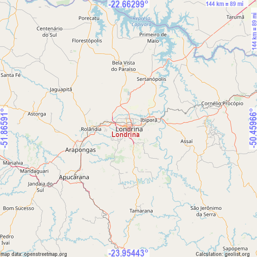
Londrina GPS coordinates[2]
23° 18' 37.008" South, 51° 9' 46.008" West
| Map corner | latitude | longitude |
|---|---|---|
| Upper-left | -22.66299°, | -51.86591° |
| Center: | -23.31028°, | -51.16278° |
| Lower-right: | -23.95443°, | -50.45966° |
| Map W x H: | 143.6×143.6 km | = 89.2×89.2mi |
| max Lat: | 2.81972° ⇑81.2% North |
| Londrina: | -23.31028° |
| min Lat: | ⇓18.8% South -33.69111° |
| min Long | Londrina | max Long |
| -72.89583° | -51.16278° | -32.41083° |
| W 16.4%⇐ | ⇒83.6% E |
Elevation
Elevation of Londrina is 605 m = 1985 ft, and this is 224.1 m = 735 ft above average elevation for this country.
| Max E: |
1603 m = 5259 ft | 26.7% |
| Londrina | 605 m 1985 ft | |
| Avg. | 380.9 m = 1250 ft | |
Min E: |
0 m = 0 ft | 73.3% |
See also: Londrina elevation on elevation.city.
Geographical zone
Londrina is located in South Torrid zone (between Equator and Tropic of Capricorn). Distance of this Southern Tropic circle is 14.1 km =8.8 mi to South.| Distance of | km | miles | from Londrina |
|---|---|---|---|
| Equator | 2591.9 | 1610.5 | to North |
| Tropic Capricorn | 14.1 | 8.8 | to South |
| Antarctic Circle | 4809.3 | 2988.4 | to South |
| South Pole | 7415.2 | 4607.6 | to South |


Nearby cities:
15 places around Londrina: (largest is in red/bold)
• Apucarana
40.5 km =25.2 mi,  228°
228°
• Arapongas
29.3 km =18.2 mi,  245°
245°
• Assaí
33.6 km =20.9 mi,  102°
102°
• Astorga
52.1 km =32.4 mi,  279°
279°
• Bela Vista do Paraíso
35 km =21.7 mi,  355°
355°
• Cambé
12.4 km =7.7 mi,  287°
287°
• Cornélio Procópio
54.6 km =33.9 mi,  74°
74°
• Florestópolis
54.7 km =34 mi,  335°
335°
• Ibiporã
12.6 km =7.8 mi, 68°
• Jandaia do Sul
58.8 km =36.5 mi,  236°
236°
• Jataizinho
19.7 km =12.2 mi, 71°
• Mandaguari
58.2 km =36.2 mi, 243°
• Porecatu
65.5 km =40.7 mi, 340°
• Rolândia
21.1 km =13.1 mi,  270°
270°
• Sertanópolis
30.8 km =19.1 mi,  24°
24°
Sources, notices
• [Note1] Compared only with cities in Brazil existing in our database
• [Src1] Map data: © OpenStreetMap contributors (CC-BY-SA)
• [Src2] Other city data from geonames.org with taken over terms of usage.
• [Src3] Geographical zone / Annual Mean Temperature by Robert A. Rohde @ Wikipedia
