Horizontina geodata
Horizontina (Rio Grande do Sul) is a populated place; located in Brazil in America/Sao_Paulo (GMT-3) time zone. With population of 14,416 people, there are 1258 cities with bigger population in this country. Compared to other cities in Brazil, 92.8% of cities are located further ↑North; 93.1% of cities are located further →East and 52.1% of cities have higher elevation than Horizontina. Note1


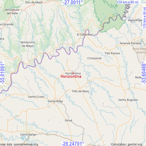
Horizontina GPS coordinates[2]
27° 37' 32.988" South, 54° 18' 28.008" West
| Map corner | latitude | longitude |
|---|---|---|
| Upper-left | -27.0011°, | -55.01091° |
| Center: | -27.62583°, | -54.30778° |
| Lower-right: | -28.24701°, | -53.60466° |
| Map W x H: | 138.5×138.5 km | = 86.1×86.1mi |
| max Lat: | 2.81972° ⇑92.8% North |
| Horizontina: | -27.62583° |
| min Lat: | ⇓7.2% South -33.69111° |
| min Long | Horizontina | max Long |
| -72.89583° | -54.30778° | -32.41083° |
| W 6.9%⇐ | ⇒93.1% E |
Elevation
Elevation of Horizontina is 323 m = 1060 ft, and this is 57.9 m = 190 ft below average elevation for this country.
| Max E: |
1603 m = 5259 ft | 52.1% |
| Avg. | 380.9 m = 1250 ft | |
| Horizontina | 323 m = 1060 ft | |
Min E: |
0 m = 0 ft | 47.9% |
See also: Brazil elevation on elevation.city.
Geographical zone
Horizontina is located in South temperate zone (between Tropic of Capricorn and the Antarctic Circle). Distance of this Southern Tropic circle is 465.8 km =289.4 mi to North.| Distance of | km | miles | from Horizontina |
|---|---|---|---|
| Equator | 3071.7 | 1908.7 | to North |
| Tropic Capricorn | 465.8 | 289.4 | to North |
| Antarctic Circle | 4329.5 | 2690.2 | to South |
| South Pole | 6935.4 | 4309.5 | to South |


Nearby cities:
15 places around Horizontina: (largest is in red/bold)
• Butia Inferior
75.3 km =46.8 mi,  228°
228°
• Cerro Largo
71.9 km =44.7 mi,  216°
216°
• Cruz Alta
132.5 km =82.3 mi,  148°
148°
• Frederico Westphalen
94.8 km =58.9 mi,  71°
71°
• Giruá
44.9 km =27.9 mi,  185°
185°
• Ijuí
93.1 km =57.8 mi,  155°
155°
• Palmeira das Missões
102.4 km =63.6 mi,  107°
107°
• Panambi
108.5 km =67.4 mi,  133°
133°
• Santa Rosa
32.2 km =20 mi,  212°
212°
• Santo Augusto
57.9 km =36 mi,  115°
115°
• Santo Ângelo
75 km =46.6 mi,  176°
176°
• Sarandi
140.7 km =87.4 mi,  104°
104°
• São Luiz Gonzaga
108.1 km =67.2 mi, 216°
• Três Passos
41.6 km =25.8 mi,  62°
62°
• Três de Maio
17.7 km =11 mi, 157°
Sources, notices
• [Note1] Compared only with cities in Brazil existing in our database
• [Src1] Map data: © OpenStreetMap contributors (CC-BY-SA)
• [Src2] Other city data from geonames.org with taken over terms of usage.
• [Src3] Geographical zone / Annual Mean Temperature by Robert A. Rohde @ Wikipedia
