Santa Rosa geodata
Santa Rosa (Rio Grande do Sul) is a populated place; located in Brazil in America/Sao_Paulo (GMT-3) time zone. With population of 58,957 people, there are 374 cities with bigger population in this country. Compared to other cities in Brazil, 93.7% of cities are located further ↑North; 93.3% of cities are located further →East and 54% of cities have higher elevation than Santa Rosa. Note1


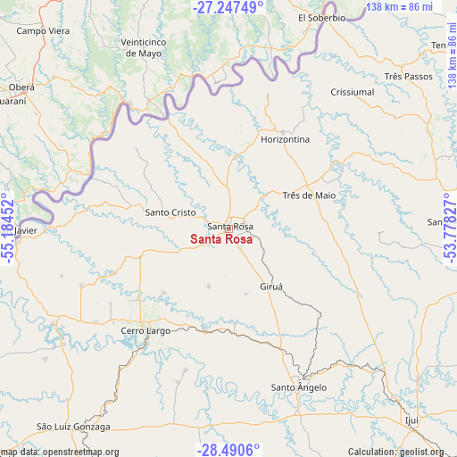
Santa Rosa GPS coordinates[2]
27° 52' 14.988" South, 54° 28' 53.004" West
| Map corner | latitude | longitude |
|---|---|---|
| Upper-left | -27.24749°, | -55.18452° |
| Center: | -27.87083°, | -54.48139° |
| Lower-right: | -28.4906°, | -53.77827° |
| Map W x H: | 138.2×138.2 km | = 85.9×85.9mi |
| max Lat: | 2.81972° ⇑93.7% North |
| Santa Rosa: | -27.87083° |
| min Lat: | ⇓6.3% South -33.69111° |
| min Long | Santa Rosa | max Long |
| -72.89583° | -54.48139° | -32.41083° |
| W 6.7%⇐ | ⇒93.3% E |
Elevation
Elevation of Santa Rosa is 284 m = 932 ft, and this is 96.9 m = 318 ft below average elevation for this country.
| Max E: |
1603 m = 5259 ft | 54% |
| Avg. | 380.9 m = 1250 ft | |
| Santa Rosa | 284 m = 932 ft | |
Min E: |
0 m = 0 ft | 46% |
See also: Santa Rosa elevation on elevation.city.
Geographical zone
Santa Rosa is located in South temperate zone (between Tropic of Capricorn and the Antarctic Circle). Distance of this Southern Tropic circle is 493 km =306.3 mi to North.| Distance of | km | miles | from Santa Rosa |
|---|---|---|---|
| Equator | 3098.9 | 1925.6 | to North |
| Tropic Capricorn | 493 | 306.3 | to North |
| Antarctic Circle | 4302.2 | 2673.3 | to South |
| South Pole | 6908.1 | 4292.5 | to South |


Nearby cities:
15 places around Santa Rosa: (largest is in red/bold)
• Butia Inferior
45.5 km =28.3 mi,  240°
240°
• Cerro Largo
39.9 km =24.8 mi,  219°
219°
• Cruz Alta
121.4 km =75.4 mi,  135°
135°
• Frederico Westphalen
121.3 km =75.4 mi,  62°
62°
• Giruá
21.8 km =13.5 mi, 143°
• Horizontina
32.2 km =20 mi,  32°
32°
• Ijuí
79.9 km =49.6 mi, 135°
• Palmeira das Missões
114.8 km =71.3 mi,  91°
91°
• Panambi
106.9 km =66.4 mi,  116°
116°
• Santo Augusto
69.3 km =43.1 mi, 88°
• Santo Ângelo
52.2 km =32.4 mi,  155°
155°
• São Luiz Gonzaga
76 km =47.2 mi, 218°
• Três Passos
71.1 km =44.2 mi,  49°
49°
• Três de Maio
26.1 km =16.2 mi,  65°
65°
• Tupanciretã
148.6 km =92.3 mi,  154°
154°
Sources, notices
• [Note1] Compared only with cities in Brazil existing in our database
• [Src1] Map data: © OpenStreetMap contributors (CC-BY-SA)
• [Src2] Other city data from geonames.org with taken over terms of usage.
• [Src3] Geographical zone / Annual Mean Temperature by Robert A. Rohde @ Wikipedia
