Cerro Largo geodata
Cerro Largo (Rio Grande do Sul) is a populated place; located in Brazil in America/Sao_Paulo (GMT-3) time zone. With population of 9,548 people, there are 1684 cities with bigger population in this country. Compared to other cities in Brazil, 94.1% of cities are located further ↑North; 93.8% of cities are located further →East and 60.9% of cities have higher elevation than Cerro Largo. Note1


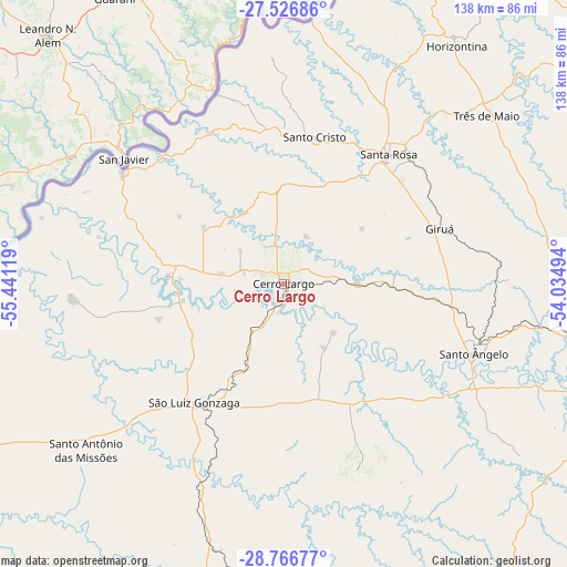
Cerro Largo GPS coordinates[2]
28° 8' 54.996" South, 54° 44' 17.016" West
| Map corner | latitude | longitude |
|---|---|---|
| Upper-left | -27.52686°, | -55.44119° |
| Center: | -28.14861°, | -54.73806° |
| Lower-right: | -28.76677°, | -54.03494° |
| Map W x H: | 137.9×137.9 km | = 85.7×85.7mi |
| max Lat: | 2.81972° ⇑94.1% North |
| Cerro Largo: | -28.14861° |
| min Lat: | ⇓5.9% South -33.69111° |
| min Long | Cerro Largo | max Long |
| -72.89583° | -54.73806° | -32.41083° |
| W 6.2%⇐ | ⇒93.8% E |
Elevation
Elevation of Cerro Largo is 200 m = 656 ft, and this is 180.9 m = 594 ft below average elevation for this country.
| Max E: |
1603 m = 5259 ft | 60.9% |
| Avg. | 380.9 m = 1250 ft | |
| Cerro Largo | 200 m = 656 ft | |
Min E: |
0 m = 0 ft | 39.1% |
See also: Brazil elevation on elevation.city.
Geographical zone
Cerro Largo is located in South temperate zone (between Tropic of Capricorn and the Antarctic Circle). Distance of this Southern Tropic circle is 523.9 km =325.5 mi to North.| Distance of | km | miles | from Cerro Largo |
|---|---|---|---|
| Equator | 3129.8 | 1944.8 | to North |
| Tropic Capricorn | 523.9 | 325.5 | to North |
| Antarctic Circle | 4271.3 | 2654.1 | to South |
| South Pole | 6877.2 | 4273.3 | to South |


Nearby cities:
15 places around Cerro Largo: (largest is in red/bold)
• Butia Inferior
16.8 km =10.4 mi,  300°
300°
• Cruz Alta
123.6 km =76.8 mi,  116°
116°
• Giruá
40.4 km =25.1 mi,  70°
70°
• Horizontina
71.9 km =44.7 mi,  36°
36°
• Ijuí
84.9 km =52.8 mi,  108°
108°
• Panambi
122.2 km =75.9 mi,  97°
97°
• Santa Rosa
39.9 km =24.8 mi, 39°
• Santiago
116.7 km =72.5 mi,  186°
186°
• Santo Augusto
100 km =62.1 mi, 70°
• Santo Ângelo
49.5 km =30.8 mi, 109°
• São Borja
136.3 km =84.7 mi,  245°
245°
• São Luiz Gonzaga
36.2 km =22.5 mi,  217°
217°
• Três Passos
110.6 km =68.7 mi,  45°
45°
• Três de Maio
64.3 km =40 mi, 49°
• Tupanciretã
136 km =84.5 mi,  139°
139°
Sources, notices
• [Note1] Compared only with cities in Brazil existing in our database
• [Src1] Map data: © OpenStreetMap contributors (CC-BY-SA)
• [Src2] Other city data from geonames.org with taken over terms of usage.
• [Src3] Geographical zone / Annual Mean Temperature by Robert A. Rohde @ Wikipedia
