Linhares geodata
Linhares (Espírito Santo) is a populated place; located in Brazil in America/Sao_Paulo (GMT-3) time zone. With population of 105,075 people, there are 218 cities with bigger population in this country. Compared to other cities in Brazil, 54.2% of cities are located further ↑North; 75.2% of cities are located further ←West and 83% of cities have higher elevation than Linhares. Note1


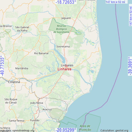
Linhares GPS coordinates[2]
19° 23' 27.996" South, 40° 4' 19.992" West
| Map corner | latitude | longitude |
|---|---|---|
| Upper-left | -18.72653°, | -40.77535° |
| Center: | -19.39111°, | -40.07222° |
| Lower-right: | -20.05299°, | -39.3691° |
| Map W x H: | 147.5×147.5 km | = 91.7×91.7mi |
| max Lat: | 2.81972° ⇑54.2% North |
| Linhares: | -19.39111° |
| min Lat: | ⇓45.8% South -33.69111° |
| min Long | Linhares | max Long |
| -72.89583° | -40.07222° | -32.41083° |
| W 75.2%⇐ | ⇒24.8% E |
Elevation
Elevation of Linhares is 36 m = 118 ft, and this is 344.9 m = 1132 ft below average elevation for this country.
| Max E: |
1603 m = 5259 ft | 83% |
| Avg. | 380.9 m = 1250 ft | |
| Linhares | 36 m = 118 ft | |
Min E: |
0 m = 0 ft | 17% |
See also: Linhares elevation on elevation.city.
Geographical zone
Linhares is located in South Torrid zone (between Equator and Tropic of Capricorn). Distance of this Southern Tropic circle is 449.8 km =279.5 mi to South.| Distance of | km | miles | from Linhares |
|---|---|---|---|
| Equator | 2156.1 | 1339.7 | to North |
| Tropic Capricorn | 449.8 | 279.5 | to South |
| Antarctic Circle | 5245.1 | 3259.2 | to South |
| South Pole | 7851 | 4878.4 | to South |


Nearby cities:
15 places around Linhares: (largest is in red/bold)
• Aracruz
52.2 km =32.4 mi,  203°
203°
• Colatina
60.8 km =37.8 mi,  254°
254°
• Fundão
69.7 km =43.3 mi,  209°
209°
• Ibiraçu
58.1 km =36.1 mi, 212°
• Itaguaçu
93.9 km =58.3 mi,  240°
240°
• João Neiva
52.3 km =32.5 mi,  218°
218°
• Marilândia
49.3 km =30.6 mi,  267°
267°
• Nova Venécia
83.2 km =51.7 mi,  335°
335°
• Pancas
83.8 km =52.1 mi,  282°
282°
• Rio Bananal
30.8 km =19.1 mi,  297°
297°
• Santa Leopoldina
92.3 km =57.4 mi, 211°
• Santa Teresa
82 km =51 mi, 222°
• Serra
85.6 km =53.2 mi, 196°
• São Mateus
77.9 km =48.4 mi,  16°
16°
• Águia Branca
83.5 km =51.9 mi, 302°
Sources, notices
• [Note1] Compared only with cities in Brazil existing in our database
• [Src1] Map data: © OpenStreetMap contributors (CC-BY-SA)
• [Src2] Other city data from geonames.org with taken over terms of usage.
• [Src3] Geographical zone / Annual Mean Temperature by Robert A. Rohde @ Wikipedia
