Goianira geodata
Goianira (Goiás) is a populated place; located in Brazil in America/Sao_Paulo (GMT-3) time zone. With population of 22,822 people, there are 837 cities with bigger population in this country. Compared to other cities in Brazil, 52% of cities are located further ↓South; 75% of cities are located further →East and 85.2% of cities have lower elevation than Goianira. Note1


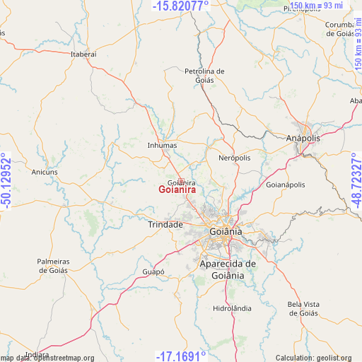
Goianira GPS coordinates[2]
16° 29' 45.996" South, 49° 25' 35.004" West
| Map corner | latitude | longitude |
|---|---|---|
| Upper-left | -15.82077°, | -50.12952° |
| Center: | -16.49611°, | -49.42639° |
| Lower-right: | -17.1691°, | -48.72327° |
| Map W x H: | 149.9×149.9 km | = 93.1×93.1mi |
| max Lat: | 2.81972° ⇑48% North |
| Goianira: | -16.49611° |
| min Lat: | ⇓52% South -33.69111° |
| min Long | Goianira | max Long |
| -72.89583° | -49.42639° | -32.41083° |
| W 25%⇐ | ⇒75% E |
Elevation
Elevation of Goianira is 760 m = 2493 ft, and this is 379.1 m = 1244 ft above average elevation for this country.
| Max E: |
1603 m = 5259 ft | 14.8% |
| Goianira | 760 m 2493 ft | |
| Avg. | 380.9 m = 1250 ft | |
Min E: |
0 m = 0 ft | 85.2% |
See also: Brazil elevation on elevation.city.
Geographical zone
Goianira is located in South Torrid zone (between Equator and Tropic of Capricorn). Distance of this Southern Tropic circle is 771.7 km =479.5 mi to South.| Distance of | km | miles | from Goianira |
|---|---|---|---|
| Equator | 1834.2 | 1139.7 | to North |
| Tropic Capricorn | 771.7 | 479.5 | to South |
| Antarctic Circle | 5567 | 3459.2 | to South |
| South Pole | 8172.9 | 5078.4 | to South |


Nearby cities:
15 places around Goianira: (largest is in red/bold)
• Anicuns
57.2 km =35.5 mi,  273°
273°
• Anápolis
53.9 km =33.5 mi,  69°
69°
• Aparecida de Goiânia
41.3 km =25.7 mi,  151°
151°
• Bela Vista de Goiás
73.1 km =45.4 mi,  136°
136°
• Goianápolis
42.9 km =26.7 mi,  92°
92°
• Goiânia
27.4 km =17 mi, 137°
• Guapó
38.8 km =24.1 mi,  196°
196°
• Hidrolândia
56 km =34.8 mi,  157°
157°
• Inhumas
17.1 km =10.6 mi,  334°
334°
• Itaberaí
66.9 km =41.6 mi,  322°
322°
• Nerópolis
24.3 km =15.1 mi, 65°
• Palmeiras de Goiás
63.3 km =39.3 mi,  237°
237°
• Petrolina de Goiás
45.6 km =28.3 mi,  11°
11°
• Senador Canedo
42.6 km =26.5 mi,  123°
123°
• Trindade
18.3 km =11.4 mi, 201°
Sources, notices
• [Note1] Compared only with cities in Brazil existing in our database
• [Src1] Map data: © OpenStreetMap contributors (CC-BY-SA)
• [Src2] Other city data from geonames.org with taken over terms of usage.
• [Src3] Geographical zone / Annual Mean Temperature by Robert A. Rohde @ Wikipedia
