Inhumas geodata
Inhumas (Goiás) is a populated place; located in Brazil in America/Sao_Paulo (GMT-3) time zone. With population of 44,058 people, there are 483 cities with bigger population in this country. Compared to other cities in Brazil, 52.5% of cities are located further ↓South; 75.7% of cities are located further →East and 85.5% of cities have lower elevation than Inhumas. Note1


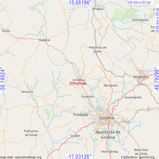
Inhumas GPS coordinates[2]
16° 21' 28.008" South, 49° 29' 45.996" West
| Map corner | latitude | longitude |
|---|---|---|
| Upper-left | -15.68196°, | -50.19924° |
| Center: | -16.35778°, | -49.49611° |
| Lower-right: | -17.03126°, | -48.79299° |
| Map W x H: | 150×150 km | = 93.2×93.2mi |
| max Lat: | 2.81972° ⇑47.5% North |
| Inhumas: | -16.35778° |
| min Lat: | ⇓52.5% South -33.69111° |
| min Long | Inhumas | max Long |
| -72.89583° | -49.49611° | -32.41083° |
| W 24.3%⇐ | ⇒75.7% E |
Elevation
Elevation of Inhumas is 763 m = 2503 ft, and this is 382.1 m = 1254 ft above average elevation for this country.
| Max E: |
1603 m = 5259 ft | 14.5% |
| Inhumas | 763 m 2503 ft | |
| Avg. | 380.9 m = 1250 ft | |
Min E: |
0 m = 0 ft | 85.5% |
See also: Inhumas elevation on elevation.city.
Geographical zone
Inhumas is located in South Torrid zone (between Equator and Tropic of Capricorn). Distance of this Southern Tropic circle is 787.1 km =489.1 mi to South.| Distance of | km | miles | from Inhumas |
|---|---|---|---|
| Equator | 1818.8 | 1130.1 | to North |
| Tropic Capricorn | 787.1 | 489.1 | to South |
| Antarctic Circle | 5582.4 | 3468.7 | to South |
| South Pole | 8188.2 | 5087.9 | to South |


Nearby cities:
15 places around Inhumas: (largest is in red/bold)
• Anicuns
51 km =31.7 mi,  256°
256°
• Anápolis
58.1 km =36.1 mi,  86°
86°
• Aparecida de Goiânia
58.3 km =36.2 mi,  152°
152°
• Goianira
17.1 km =10.6 mi, 154°
• Goianápolis
53.1 km =33 mi,  108°
108°
• Goiânia
44 km =27.3 mi,  144°
144°
• Guapó
52.7 km =32.7 mi,  184°
184°
• Hidrolândia
73 km =45.4 mi,  156°
156°
• Itaberaí
50.3 km =31.3 mi,  318°
318°
• Jaraguá
69 km =42.9 mi,  14°
14°
• Nerópolis
30.1 km =18.7 mi,  100°
100°
• Palmeiras de Goiás
67.6 km =42 mi,  222°
222°
• Petrolina de Goiás
33.7 km =20.9 mi,  30°
30°
• Senador Canedo
58 km =36 mi,  132°
132°
• Trindade
32.4 km =20.1 mi, 178°
Sources, notices
• [Note1] Compared only with cities in Brazil existing in our database
• [Src1] Map data: © OpenStreetMap contributors (CC-BY-SA)
• [Src2] Other city data from geonames.org with taken over terms of usage.
• [Src3] Geographical zone / Annual Mean Temperature by Robert A. Rohde @ Wikipedia
