Toledo geodata
Toledo (Paraná) is a populated place; located in Brazil in America/Sao_Paulo (GMT-3) time zone. With population of 119,313 people, there are 188 cities with bigger population in this country. Compared to other cities in Brazil, 87.4% of cities are located further ↑North; 92% of cities are located further →East and 68.5% of cities have lower elevation than Toledo. Note1


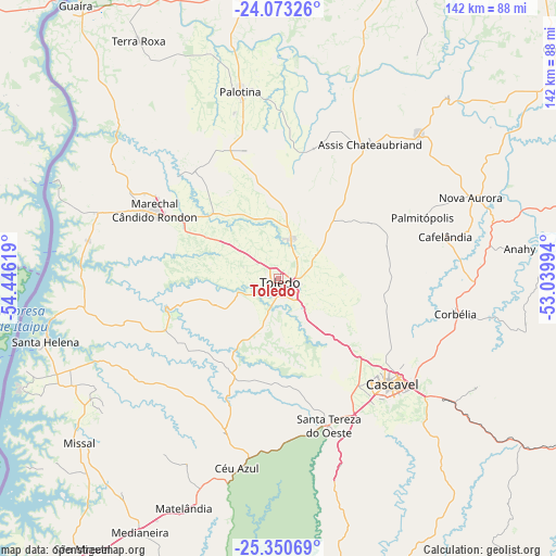
Toledo GPS coordinates[2]
24° 42' 48.996" South, 53° 44' 35.016" West
| Map corner | latitude | longitude |
|---|---|---|
| Upper-left | -24.07326°, | -54.44619° |
| Center: | -24.71361°, | -53.74306° |
| Lower-right: | -25.35069°, | -53.03994° |
| Map W x H: | 142×142 km | = 88.2×88.2mi |
| max Lat: | 2.81972° ⇑87.4% North |
| Toledo: | -24.71361° |
| min Lat: | ⇓12.6% South -33.69111° |
| min Long | Toledo | max Long |
| -72.89583° | -53.74306° | -32.41083° |
| W 8%⇐ | ⇒92% E |
Elevation
Elevation of Toledo is 562 m = 1844 ft, and this is 181.1 m = 594 ft above average elevation for this country.
| Max E: |
1603 m = 5259 ft | 31.5% |
| Toledo | 562 m 1844 ft | |
| Avg. | 380.9 m = 1250 ft | |
Min E: |
0 m = 0 ft | 68.5% |
See also: Toledo elevation on elevation.city.
Geographical zone
Toledo is located in South temperate zone (between Tropic of Capricorn and the Antarctic Circle). Distance of this Southern Tropic circle is 142 km =88.2 mi to North.| Distance of | km | miles | from Toledo |
|---|---|---|---|
| Equator | 2747.9 | 1707.5 | to North |
| Tropic Capricorn | 142 | 88.2 | to North |
| Antarctic Circle | 4653.3 | 2891.4 | to South |
| South Pole | 7259.2 | 4510.7 | to South |


Nearby cities:
15 places around Toledo: (largest is in red/bold)
• Alto Piquiri
82.2 km =51.1 mi,  21°
21°
• Altãnia
94.7 km =58.8 mi,  350°
350°
• Cascavel
39.6 km =24.6 mi,  132°
132°
• Corbélia
45.1 km =28 mi,  102°
102°
• Eldorado
116.7 km =72.5 mi,  331°
331°
• Guaraniaçu
97.3 km =60.5 mi,  116°
116°
• Iporã
79.1 km =49.2 mi,  2°
2°
• Marechal Cândido Rondon
36.2 km =22.5 mi,  298°
298°
• Matelândia
63.9 km =39.7 mi,  203°
203°
• Medianeira
73.7 km =45.8 mi,  208°
208°
• Moreira Sales
103.9 km =64.6 mi,  45°
45°
• Palotina
48.8 km =30.3 mi, 348°
• Realeza
119.2 km =74.1 mi,  169°
169°
• São Miguel do Iguaçu
86.4 km =53.7 mi,  215°
215°
• Umuarama
113.5 km =70.5 mi, 21°
Sources, notices
• [Note1] Compared only with cities in Brazil existing in our database
• [Src1] Map data: © OpenStreetMap contributors (CC-BY-SA)
• [Src2] Other city data from geonames.org with taken over terms of usage.
• [Src3] Geographical zone / Annual Mean Temperature by Robert A. Rohde @ Wikipedia
