Inhapim geodata
Inhapim (Minas Gerais) is a populated place; located in Brazil in America/Sao_Paulo (GMT-3) time zone. With population of 13,593 people, there are 1321 cities with bigger population in this country. Compared to other cities in Brazil, 54.8% of cities are located further ↑North; 65.3% of cities are located further ←West and 64.9% of cities have lower elevation than Inhapim. Note1


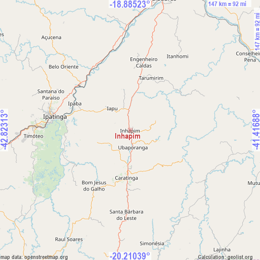
Inhapim GPS coordinates[2]
19° 32' 57.012" South, 42° 7' 12" West
| Map corner | latitude | longitude |
|---|---|---|
| Upper-left | -18.88523°, | -42.82313° |
| Center: | -19.54917°, | -42.12° |
| Lower-right: | -20.21039°, | -41.41688° |
| Map W x H: | 147.3×147.3 km | = 91.5×91.5mi |
| max Lat: | 2.81972° ⇑54.8% North |
| Inhapim: | -19.54917° |
| min Lat: | ⇓45.2% South -33.69111° |
| min Long | Inhapim | max Long |
| -72.89583° | -42.12° | -32.41083° |
| W 65.3%⇐ | ⇒34.7% E |
Elevation
Elevation of Inhapim is 525 m = 1722 ft, and this is 144.1 m = 473 ft above average elevation for this country.
| Max E: |
1603 m = 5259 ft | 35.1% |
| Inhapim | 525 m 1722 ft | |
| Avg. | 380.9 m = 1250 ft | |
Min E: |
0 m = 0 ft | 64.9% |
See also: Brazil elevation on elevation.city.
Geographical zone
Inhapim is located in South Torrid zone (between Equator and Tropic of Capricorn). Distance of this Southern Tropic circle is 432.3 km =268.6 mi to South.| Distance of | km | miles | from Inhapim |
|---|---|---|---|
| Equator | 2173.7 | 1350.7 | to North |
| Tropic Capricorn | 432.3 | 268.6 | to South |
| Antarctic Circle | 5227.5 | 3248.2 | to South |
| South Pole | 7833.4 | 4867.4 | to South |


Nearby cities:
15 places around Inhapim: (largest is in red/bold)
• Açucena
69.3 km =43.1 mi,  319°
319°
• Belo Oriente
52.9 km =32.9 mi,  313°
313°
• Bom Jesus do Galho
37.3 km =23.2 mi,  213°
213°
• Caratinga
26.8 km =16.7 mi,  184°
184°
• Conselheiro Pena
79.8 km =49.6 mi,  58°
58°
• Coronel Fabriciano
53.4 km =33.2 mi,  273°
273°
• Governador Valadares
79.7 km =49.5 mi,  12°
12°
• Ipaba
34.8 km =21.6 mi,  295°
295°
• Ipatinga
44.6 km =27.7 mi,  281°
281°
• Lajinha
84.8 km =52.7 mi,  142°
142°
• Manhuaçu
79.3 km =49.3 mi,  173°
173°
• Matipó
84.9 km =52.8 mi,  195°
195°
• Mutum
76.6 km =47.6 mi,  111°
111°
• Santana do Paraíso
51.4 km =31.9 mi,  293°
293°
• Timóteo
55.6 km =34.5 mi, 266°
Sources, notices
• [Note1] Compared only with cities in Brazil existing in our database
• [Src1] Map data: © OpenStreetMap contributors (CC-BY-SA)
• [Src2] Other city data from geonames.org with taken over terms of usage.
• [Src3] Geographical zone / Annual Mean Temperature by Robert A. Rohde @ Wikipedia
