Itaberaí geodata
Itaberaí (Goiás) is a populated place; located in Brazil in America/Sao_Paulo (GMT-3) time zone. With population of 22,129 people, there are 864 cities with bigger population in this country. Compared to other cities in Brazil, 53.3% of cities are located further ↓South; 77.3% of cities are located further →East and 81.1% of cities have lower elevation than Itaberaí. Note1


Itaberaí GPS coordinates[2]
16° 1' 13.008" South, 49° 48' 37.008" West
| Map corner | latitude | longitude |
|---|---|---|
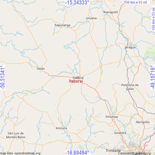
| Upper-left | -15.34333°, | -50.51341° |
| Center: | -16.02028°, | -49.81028° |
| Lower-right: | -16.69494°, | -49.10716° |
| Map W x H: | 150.3×150.3 km | = 93.4×93.4mi |
| max Lat: | 2.81972° ⇑46.7% North |
| Itaberaí: | -16.02028° |
| min Lat: | ⇓53.3% South -33.69111° |
| min Long | Itaberaí | max Long |
| -72.89583° | -49.81028° | -32.41083° |
| W 22.7%⇐ | ⇒77.3% E |
Elevation
Elevation of Itaberaí is 705 m = 2313 ft, and this is 324.1 m = 1063 ft above average elevation for this country.
| Max E: |
1603 m = 5259 ft | 18.9% |
| Itaberaí | 705 m 2313 ft | |
| Avg. | 380.9 m = 1250 ft | |
Min E: |
0 m = 0 ft | 81.1% |
See also: Brazil elevation on elevation.city.
Geographical zone
Itaberaí is located in South Torrid zone (between Equator and Tropic of Capricorn). Distance of this Southern Tropic circle is 824.6 km =512.4 mi to South.| Distance of | km | miles | from Itaberaí |
|---|---|---|---|
| Equator | 1781.3 | 1106.8 | to North |
| Tropic Capricorn | 824.6 | 512.4 | to South |
| Antarctic Circle | 5619.9 | 3492 | to South |
| South Pole | 8225.8 | 5111.3 | to South |


Nearby cities:
15 places around Itaberaí: (largest is in red/bold)
• Anicuns
51.6 km =32.1 mi,  198°
198°
• Carmo do Rio Verde
74.9 km =46.5 mi,  8°
8°
• Ceres
82.3 km =51.1 mi,  15°
15°
• Firminópolis
81.8 km =50.8 mi,  220°
220°
• Goianira
66.9 km =41.6 mi,  142°
142°
• Goiás
36.5 km =22.7 mi,  285°
285°
• Inhumas
50.3 km =31.3 mi, 138°
• Itapuranga
53 km =32.9 mi,  343°
343°
• Jaraguá
58.7 km =36.5 mi,  60°
60°
• Nerópolis
76.4 km =47.5 mi,  124°
124°
• Petrolina de Goiás
51.1 km =31.8 mi,  99°
99°
• Rialma
82.1 km =51 mi, 17°
• São Luís de Montes Belos
82.1 km =51 mi,  226°
226°
• Trindade
77.9 km =48.4 mi,  153°
153°
• Uruana
59.1 km =36.7 mi, 13°
Sources, notices
• [Note1] Compared only with cities in Brazil existing in our database
• [Src1] Map data: © OpenStreetMap contributors (CC-BY-SA)
• [Src2] Other city data from geonames.org with taken over terms of usage.
• [Src3] Geographical zone / Annual Mean Temperature by Robert A. Rohde @ Wikipedia
