Anicuns geodata
Anicuns (Goiás) is a populated place; located in Brazil in America/Sao_Paulo (GMT-3) time zone. With population of 15,684 people, there are 1177 cities with bigger population in this country. Compared to other cities in Brazil, 52.2% of cities are located further ↓South; 78% of cities are located further →East and 81.3% of cities have lower elevation than Anicuns. Note1


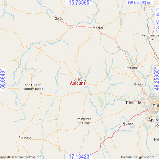
Anicuns GPS coordinates[2]
16° 27' 39.996" South, 49° 57' 42.012" West
| Map corner | latitude | longitude |
|---|---|---|
| Upper-left | -15.78565°, | -50.6648° |
| Center: | -16.46111°, | -49.96167° |
| Lower-right: | -17.13423°, | -49.25855° |
| Map W x H: | 149.9×150 km | = 93.1×93.2mi |
| max Lat: | 2.81972° ⇑47.8% North |
| Anicuns: | -16.46111° |
| min Lat: | ⇓52.2% South -33.69111° |
| min Long | Anicuns | max Long |
| -72.89583° | -49.96167° | -32.41083° |
| W 22%⇐ | ⇒78% E |
Elevation
Elevation of Anicuns is 708 m = 2323 ft, and this is 327.1 m = 1073 ft above average elevation for this country.
| Max E: |
1603 m = 5259 ft | 18.7% |
| Anicuns | 708 m 2323 ft | |
| Avg. | 380.9 m = 1250 ft | |
Min E: |
0 m = 0 ft | 81.3% |
See also: Brazil elevation on elevation.city.
Geographical zone
Anicuns is located in South Torrid zone (between Equator and Tropic of Capricorn). Distance of this Southern Tropic circle is 775.6 km =481.9 mi to South.| Distance of | km | miles | from Anicuns |
|---|---|---|---|
| Equator | 1830.3 | 1137.3 | to North |
| Tropic Capricorn | 775.6 | 481.9 | to South |
| Antarctic Circle | 5570.9 | 3461.6 | to South |
| South Pole | 8176.8 | 5080.8 | to South |


Nearby cities:
15 places around Anicuns: (largest is in red/bold)
• Aparecida de Goiânia
86.4 km =53.7 mi,  117°
117°
• Firminópolis
39 km =24.2 mi,  249°
249°
• Goianira
57.2 km =35.5 mi,  93°
93°
• Goiás
61.6 km =38.3 mi,  341°
341°
• Goiânia
79.2 km =49.2 mi,  107°
107°
• Guapó
61.5 km =38.2 mi,  131°
131°
• Hidrolândia
96 km =59.7 mi, 125°
• Inhumas
51 km =31.7 mi,  76°
76°
• Itaberaí
51.6 km =32.1 mi,  18°
18°
• Nerópolis
79.5 km =49.4 mi, 85°
• Palmeiras de Goiás
38.4 km =23.9 mi,  174°
174°
• Paraúna
74.9 km =46.5 mi,  223°
223°
• Petrolina de Goiás
78 km =48.5 mi,  58°
58°
• São Luís de Montes Belos
44.3 km =27.5 mi,  260°
260°
• Trindade
54.6 km =33.9 mi, 112°
Sources, notices
• [Note1] Compared only with cities in Brazil existing in our database
• [Src1] Map data: © OpenStreetMap contributors (CC-BY-SA)
• [Src2] Other city data from geonames.org with taken over terms of usage.
• [Src3] Geographical zone / Annual Mean Temperature by Robert A. Rohde @ Wikipedia
