Barroso geodata
Barroso (Minas Gerais) is a populated place; located in Brazil in America/Sao_Paulo (GMT-3) time zone. With population of 16,975 people, there are 1096 cities with bigger population in this country. Compared to other cities in Brazil, 64.3% of cities are located further ↑North; 56% of cities are located further ←West and 96.6% of cities have lower elevation than Barroso. Note1


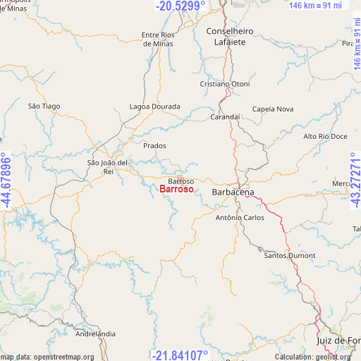
Barroso GPS coordinates[2]
21° 11' 12.984" South, 43° 58' 32.988" West
| Map corner | latitude | longitude |
|---|---|---|
| Upper-left | -20.5299°, | -44.67896° |
| Center: | -21.18694°, | -43.97583° |
| Lower-right: | -21.84107°, | -43.27271° |
| Map W x H: | 145.8×145.8 km | = 90.6×90.6mi |
| max Lat: | 2.81972° ⇑64.3% North |
| Barroso: | -21.18694° |
| min Lat: | ⇓35.7% South -33.69111° |
| min Long | Barroso | max Long |
| -72.89583° | -43.97583° | -32.41083° |
| W 56%⇐ | ⇒44% E |
Elevation
Elevation of Barroso is 927 m = 3041 ft, and this is 546.1 m = 1792 ft above average elevation for this country.
| Max E: |
1603 m = 5259 ft | 3.4% |
| Barroso | 927 m 3041 ft | |
| Avg. | 380.9 m = 1250 ft | |
Min E: |
0 m = 0 ft | 96.6% |
See also: Brazil elevation on elevation.city.
Geographical zone
Barroso is located in South Torrid zone (between Equator and Tropic of Capricorn). Distance of this Southern Tropic circle is 250.2 km =155.5 mi to South.| Distance of | km | miles | from Barroso |
|---|---|---|---|
| Equator | 2355.8 | 1463.8 | to North |
| Tropic Capricorn | 250.2 | 155.5 | to South |
| Antarctic Circle | 5045.4 | 3135.1 | to South |
| South Pole | 7651.3 | 4754.3 | to South |


Nearby cities:
15 places around Barroso: (largest is in red/bold)
• Andrelândia
70.5 km =43.8 mi,  209°
209°
• Barbacena
21.4 km =13.3 mi,  101°
101°
• Bom Sucesso
82.9 km =51.5 mi,  281°
281°
• Carandaí
31.3 km =19.4 mi,  34°
34°
• Congonhas
76.8 km =47.7 mi,  9°
9°
• Conselheiro Lafaiete
61.8 km =38.4 mi,  18°
18°
• Juiz de Fora
91.2 km =56.7 mi,  134°
134°
• Lima Duarte
75.3 km =46.8 mi,  165°
165°
• Ouro Branco
79.4 km =49.3 mi, 21°
• Rio Novo
93.8 km =58.3 mi,  110°
110°
• Rio Pomba
83.1 km =51.6 mi, 96°
• Santos Dumont
53.1 km =33 mi,  124°
124°
• São João del Rei
30.2 km =18.8 mi, 280°
• Tiradentes
22.6 km =14 mi,  292°
292°
• Tocantins
99.3 km =61.7 mi,  89°
89°
Sources, notices
• [Note1] Compared only with cities in Brazil existing in our database
• [Src1] Map data: © OpenStreetMap contributors (CC-BY-SA)
• [Src2] Other city data from geonames.org with taken over terms of usage.
• [Src3] Geographical zone / Annual Mean Temperature by Robert A. Rohde @ Wikipedia
