Tiradentes geodata
Tiradentes (Minas Gerais) is a populated place; located in Brazil in America/Sao_Paulo (GMT-3) time zone. With population of 4,439 people, there are 1946 cities with bigger population in this country. Compared to other cities in Brazil, 63.7% of cities are located further ↑North; 54.9% of cities are located further ←West and 96.7% of cities have lower elevation than Tiradentes. Note1


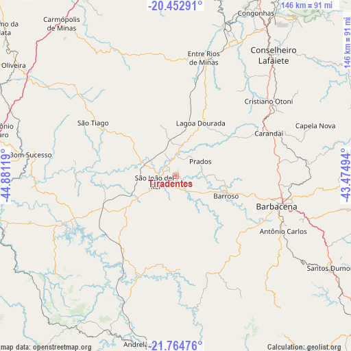
Tiradentes GPS coordinates[2]
21° 6' 37.008" South, 44° 10' 41.016" West
| Map corner | latitude | longitude |
|---|---|---|
| Upper-left | -20.45291°, | -44.88119° |
| Center: | -21.11028°, | -44.17806° |
| Lower-right: | -21.76476°, | -43.47494° |
| Map W x H: | 145.9×145.9 km | = 90.7×90.7mi |
| max Lat: | 2.81972° ⇑63.7% North |
| Tiradentes: | -21.11028° |
| min Lat: | ⇓36.3% South -33.69111° |
| min Long | Tiradentes | max Long |
| -72.89583° | -44.17806° | -32.41083° |
| W 54.9%⇐ | ⇒45.1% E |
Elevation
Elevation of Tiradentes is 930 m = 3051 ft, and this is 549.1 m = 1802 ft above average elevation for this country.
| Max E: |
1603 m = 5259 ft | 3.3% |
| Tiradentes | 930 m 3051 ft | |
| Avg. | 380.9 m = 1250 ft | |
Min E: |
0 m = 0 ft | 96.7% |
See also: Brazil elevation on elevation.city.
Geographical zone
Tiradentes is located in South Torrid zone (between Equator and Tropic of Capricorn). Distance of this Southern Tropic circle is 258.7 km =160.7 mi to South.| Distance of | km | miles | from Tiradentes |
|---|---|---|---|
| Equator | 2347.2 | 1458.5 | to North |
| Tropic Capricorn | 258.7 | 160.7 | to South |
| Antarctic Circle | 5053.9 | 3140.3 | to South |
| South Pole | 7659.8 | 4759.6 | to South |


Nearby cities:
15 places around Tiradentes: (largest is in red/bold)
• Andrelândia
71.3 km =44.3 mi,  190°
190°
• Barbacena
43.9 km =27.3 mi,  107°
107°
• Barroso
22.6 km =14 mi, 112°
• Bom Sucesso
60.8 km =37.8 mi,  278°
278°
• Carandaí
42.3 km =26.3 mi,  65°
65°
• Congonhas
75 km =46.6 mi,  26°
26°
• Conselheiro Lafaiete
64.5 km =40.1 mi,  39°
39°
• Lavras
86.5 km =53.7 mi,  260°
260°
• Lima Duarte
90.6 km =56.3 mi,  153°
153°
• Oliveira
81.6 km =50.7 mi,  304°
304°
• Ouro Branco
82.3 km =51.1 mi, 37°
• Perdões
94.8 km =58.9 mi,  271°
271°
• Santo Antônio do Amparo
79 km =49.1 mi, 283°
• Santos Dumont
75.4 km =46.9 mi,  120°
120°
• São João del Rei
9.1 km =5.7 mi,  252°
252°
Sources, notices
• [Note1] Compared only with cities in Brazil existing in our database
• [Src1] Map data: © OpenStreetMap contributors (CC-BY-SA)
• [Src2] Other city data from geonames.org with taken over terms of usage.
• [Src3] Geographical zone / Annual Mean Temperature by Robert A. Rohde @ Wikipedia
