Mutuípe geodata
Mutuípe (Bahia) is a populated place; located in Brazil in America/Bahia (GMT-3) time zone. With population of 10,016 people, there are 1650 cities with bigger population in this country. Compared to other cities in Brazil, 59.6% of cities are located further ↓South; 77.4% of cities are located further ←West and 59.6% of cities have higher elevation than Mutuípe. Note1


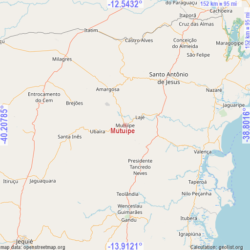
Mutuípe GPS coordinates[2]
13° 13' 42.996" South, 39° 30' 16.992" West
| Map corner | latitude | longitude |
|---|---|---|
| Upper-left | -12.5432°, | -40.20785° |
| Center: | -13.22861°, | -39.50472° |
| Lower-right: | -13.9121°, | -38.8016° |
| Map W x H: | 152.2×152.2 km | = 94.6×94.6mi |
| max Lat: | 2.81972° ⇑40.4% North |
| Mutuípe: | -13.22861° |
| min Lat: | ⇓59.6% South -33.69111° |
| min Long | Mutuípe | max Long |
| -72.89583° | -39.50472° | -32.41083° |
| W 77.4%⇐ | ⇒22.6% E |
Elevation
Elevation of Mutuípe is 219 m = 719 ft, and this is 161.9 m = 531 ft below average elevation for this country.
| Max E: |
1603 m = 5259 ft | 59.6% |
| Avg. | 380.9 m = 1250 ft | |
| Mutuípe | 219 m = 719 ft | |
Min E: |
0 m = 0 ft | 40.4% |
See also: Brazil elevation on elevation.city.
Geographical zone
Mutuípe is located in South Torrid zone (between Equator and Tropic of Capricorn). Distance of this Southern Tropic circle is 1135 km =705.3 mi to South.| Distance of | km | miles | from Mutuípe |
|---|---|---|---|
| Equator | 1470.9 | 914 | to North |
| Tropic Capricorn | 1135 | 705.3 | to South |
| Antarctic Circle | 5930.3 | 3684.9 | to South |
| South Pole | 8536.2 | 5304.1 | to South |


Nearby cities:
15 places around Mutuípe: (largest is in red/bold)
• Amargosa
24.6 km =15.3 mi,  333°
333°
• Castro Alves
52.1 km =32.4 mi,  9°
9°
• Conceição do Almeida
61.7 km =38.3 mi,  35°
35°
• Cruz das Almas
75.9 km =47.2 mi, 35°
• Gandu
57.3 km =35.6 mi,  178°
178°
• Ituberá
68.3 km =42.4 mi,  145°
145°
• Jaguaquara
60.6 km =37.7 mi,  236°
236°
• Muritiba
44.3 km =27.5 mi, 38°
• Nazaré
57.3 km =35.6 mi,  67°
67°
• Santa Inês
34.7 km =21.6 mi,  258°
258°
• Santo Antônio de Jesus
39.1 km =24.3 mi, 42°
• Sobradinho
62.1 km =38.6 mi, 44°
• Taperoá
55.8 km =34.7 mi,  128°
128°
• Ubaíra
17.7 km =11 mi, 255°
• Valença
49.3 km =30.6 mi,  108°
108°
Sources, notices
• [Note1] Compared only with cities in Brazil existing in our database
• [Src1] Map data: © OpenStreetMap contributors (CC-BY-SA)
• [Src2] Other city data from geonames.org with taken over terms of usage.
• [Src3] Geographical zone / Annual Mean Temperature by Robert A. Rohde @ Wikipedia
