Marechal Cândido Rondon geodata
Marechal Cândido Rondon (Paraná) is a populated place; located in Brazil in America/Sao_Paulo (GMT-3) time zone. With population of 43,028 people, there are 494 cities with bigger population in this country. Compared to other cities in Brazil, 87.1% of cities are located further ↑North; 92.6% of cities are located further →East and 55.5% of cities have lower elevation than Marechal Cândido Rondon. Note1
Current local time in Marechal Cândido Rondon:
08:14 PM, TuesdayDifference from your time zone: hours


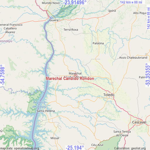
Marechal Cândido Rondon GPS coordinates[2]
24° 33' 21.996" South, 54° 3' 24.012" West
| Map corner | latitude | longitude |
|---|---|---|
| Upper-left | -23.91496°, | -54.7598° |
| Center: | -24.55611°, | -54.05667° |
| Lower-right: | -25.194°, | -53.35355° |
| Map W x H: | 142.2×142.2 km | = 88.4×88.4mi |
| max Lat: | 2.81972° ⇑87.1% North |
| Marechal Cândido Rondon: | -24.55611° |
| min Lat: | ⇓12.9% South -33.69111° |
| min Long | Marechal Cândi | max Long |
| -72.89583° | -54.05667° | -32.41083° |
| W 7.4%⇐ | ⇒92.6% E |
Elevation
Elevation of Marechal Cândido Rondon is 425 m = 1394 ft, and this is 44.1 m = 145 ft above average elevation for this country.
| Max E: |
1603 m = 5259 ft | 44.5% |
| Marechal Cândido Rondon | 425 m 1394 ft | |
| Avg. | 380.9 m = 1250 ft | |
Min E: |
0 m = 0 ft | 55.5% |
See also: Marechal Cândido Rondon elevation on elevation.city.
Geographical zone
Marechal Cândido Rondon is located in South temperate zone (between Tropic of Capricorn and the Antarctic Circle). Distance of this Southern Tropic circle is 124.5 km =77.4 mi to North.| Distance of | km | miles | from Marechal Cândido Rondon |
|---|---|---|---|
| Equator | 2730.4 | 1696.6 | to North |
| Tropic Capricorn | 124.5 | 77.4 | to North |
| Antarctic Circle | 4670.8 | 2902.3 | to South |
| South Pole | 7276.7 | 4521.5 | to South |


Nearby cities:
15 places around Marechal Cândido Rondon: (largest is in red/bold)
• Alto Piquiri
85.7 km =53.3 mi,  46°
46°
• Altãnia
77.4 km =48.1 mi,  11°
11°
• Cascavel
75.3 km =46.8 mi,  126°
126°
• Corbélia
80.4 km =50 mi,  109°
109°
• Eldorado
88.6 km =55.1 mi,  344°
344°
• Foz do Iguaçu
122.6 km =76.2 mi,  205°
205°
• Iguatemi
110 km =68.4 mi,  332°
332°
• Iporã
71.1 km =44.2 mi,  30°
30°
• Matelândia
76.4 km =47.5 mi,  175°
175°
• Medianeira
82.3 km =51.1 mi, 182°
• Moreira Sales
119.7 km =74.4 mi,  62°
62°
• Palotina
37.4 km =23.2 mi,  35°
35°
• São Miguel do Iguaçu
89.9 km =55.9 mi,  191°
191°
• Toledo
36.2 km =22.5 mi,  118°
118°
• Umuarama
115 km =71.5 mi, 40°
Sources, notices
• [Note1] Compared only with cities in Brazil existing in our database
• [Src1] Map data: © OpenStreetMap contributors (CC-BY-SA)
• [Src2] Other city data from geonames.org with taken over terms of usage.
• [Src3] Geographical zone / Annual Mean Temperature by Robert A. Rohde @ Wikipedia
