Caratinga geodata
Caratinga (Minas Gerais) is a populated place; located in Brazil in America/Sao_Paulo (GMT-3) time zone. With population of 60,066 people, there are 369 cities with bigger population in this country. Compared to other cities in Brazil, 55.8% of cities are located further ↑North; 65.2% of cities are located further ←West and 71.4% of cities have lower elevation than Caratinga. Note1


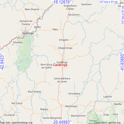
Caratinga GPS coordinates[2]
19° 47' 22.992" South, 42° 8' 21.012" West
| Map corner | latitude | longitude |
|---|---|---|
| Upper-left | -19.12676°, | -42.8423° |
| Center: | -19.78972°, | -42.13917° |
| Lower-right: | -20.44993°, | -41.43605° |
| Map W x H: | 147.1×147.1 km | = 91.4×91.4mi |
| max Lat: | 2.81972° ⇑55.8% North |
| Caratinga: | -19.78972° |
| min Lat: | ⇓44.2% South -33.69111° |
| min Long | Caratinga | max Long |
| -72.89583° | -42.13917° | -32.41083° |
| W 65.2%⇐ | ⇒34.8% E |
Elevation
Elevation of Caratinga is 586 m = 1923 ft, and this is 205.1 m = 673 ft above average elevation for this country.
| Max E: |
1603 m = 5259 ft | 28.6% |
| Caratinga | 586 m 1923 ft | |
| Avg. | 380.9 m = 1250 ft | |
Min E: |
0 m = 0 ft | 71.4% |
See also: Caratinga elevation on elevation.city.
Geographical zone
Caratinga is located in South Torrid zone (between Equator and Tropic of Capricorn). Distance of this Southern Tropic circle is 405.5 km =252 mi to South.| Distance of | km | miles | from Caratinga |
|---|---|---|---|
| Equator | 2200.4 | 1367.3 | to North |
| Tropic Capricorn | 405.5 | 252 | to South |
| Antarctic Circle | 5200.8 | 3231.6 | to South |
| South Pole | 7806.7 | 4850.9 | to South |


Nearby cities:
15 places around Caratinga: (largest is in red/bold)
• Belo Oriente
72.9 km =45.3 mi,  330°
330°
• Bom Jesus do Galho
19 km =11.8 mi,  256°
256°
• Coronel Fabriciano
59.5 km =37 mi,  300°
300°
• Inhapim
26.8 km =16.7 mi,  4°
4°
• Ipaba
51.1 km =31.8 mi,  324°
324°
• Ipatinga
54.9 km =34.1 mi,  310°
310°
• Irupi
80.8 km =50.2 mi,  139°
139°
• Lajinha
67.3 km =41.8 mi,  126°
126°
• Manhuaçu
53.2 km =33.1 mi,  168°
168°
• Manhumirim
65.9 km =40.9 mi,  163°
163°
• Matipó
58.9 km =36.6 mi,  201°
201°
• Mutum
73.3 km =45.5 mi,  90°
90°
• Rio Casca
72.2 km =44.9 mi,  227°
227°
• Santana do Paraíso
65.3 km =40.6 mi, 316°
• Timóteo
58.2 km =36.2 mi,  293°
293°
Sources, notices
• [Note1] Compared only with cities in Brazil existing in our database
• [Src1] Map data: © OpenStreetMap contributors (CC-BY-SA)
• [Src2] Other city data from geonames.org with taken over terms of usage.
• [Src3] Geographical zone / Annual Mean Temperature by Robert A. Rohde @ Wikipedia
