Manhumirim geodata
Manhumirim (Minas Gerais) is a populated place; located in Brazil in America/Sao_Paulo (GMT-3) time zone. With population of 15,544 people, there are 1188 cities with bigger population in this country. Compared to other cities in Brazil, 59.1% of cities are located further ↑North; 66% of cities are located further ←West and 73% of cities have lower elevation than Manhumirim. Note1


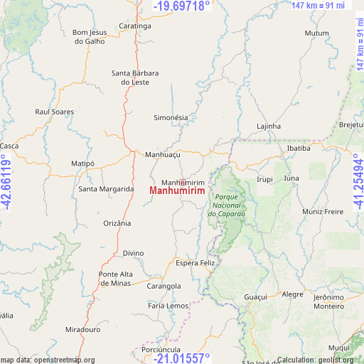
Manhumirim GPS coordinates[2]
20° 21' 28.008" South, 41° 57' 29.016" West
| Map corner | latitude | longitude |
|---|---|---|
| Upper-left | -19.69718°, | -42.66119° |
| Center: | -20.35778°, | -41.95806° |
| Lower-right: | -21.01557°, | -41.25494° |
| Map W x H: | 146.6×146.6 km | = 91.1×91.1mi |
| max Lat: | 2.81972° ⇑59.1% North |
| Manhumirim: | -20.35778° |
| min Lat: | ⇓40.9% South -33.69111° |
| min Long | Manhumirim | max Long |
| -72.89583° | -41.95806° | -32.41083° |
| W 66%⇐ | ⇒34% E |
Elevation
Elevation of Manhumirim is 603 m = 1978 ft, and this is 222.1 m = 729 ft above average elevation for this country.
| Max E: |
1603 m = 5259 ft | 27% |
| Manhumirim | 603 m 1978 ft | |
| Avg. | 380.9 m = 1250 ft | |
Min E: |
0 m = 0 ft | 73% |
See also: Brazil elevation on elevation.city.
Geographical zone
Manhumirim is located in South Torrid zone (between Equator and Tropic of Capricorn). Distance of this Southern Tropic circle is 342.3 km =212.7 mi to South.| Distance of | km | miles | from Manhumirim |
|---|---|---|---|
| Equator | 2263.6 | 1406.5 | to North |
| Tropic Capricorn | 342.3 | 212.7 | to South |
| Antarctic Circle | 5137.6 | 3192.4 | to South |
| South Pole | 7743.5 | 4811.6 | to South |


Nearby cities:
15 places around Manhumirim: (largest is in red/bold)
• Alegre
63.2 km =39.3 mi,  135°
135°
• Bom Jesus do Galho
69.7 km =43.3 mi,  327°
327°
• Carangola
42.4 km =26.3 mi,  190°
190°
• Caratinga
65.9 km =40.9 mi,  343°
343°
• Espera Feliz
33 km =20.5 mi,  170°
170°
• Guaçuí
54.8 km =34.1 mi,  148°
148°
• Ibatiba
48.7 km =30.3 mi,  73°
73°
• Irupi
33.1 km =20.6 mi,  87°
87°
• Iúna
44 km =27.3 mi, 88°
• Lajinha
41.8 km =26 mi,  56°
56°
• Manhuaçu
13.6 km =8.5 mi,  324°
324°
• Matipó
40.8 km =25.4 mi,  281°
281°
• Muniz Freire
58 km =36 mi,  101°
101°
• Porciúncula
67.8 km =42.1 mi, 187°
• Rio Casca
73.7 km =45.8 mi, 281°
Sources, notices
• [Note1] Compared only with cities in Brazil existing in our database
• [Src1] Map data: © OpenStreetMap contributors (CC-BY-SA)
• [Src2] Other city data from geonames.org with taken over terms of usage.
• [Src3] Geographical zone / Annual Mean Temperature by Robert A. Rohde @ Wikipedia
