Bauru geodata
Bauru (São Paulo) is a seat of a second-order administrative division; located in Brazil in America/Sao_Paulo (GMT-3) time zone. With population of 335,024 people, there are 60 cities with bigger population in this country. Compared to other cities in Brazil, 72.1% of cities are located further ↑North; 71.8% of cities are located further →East and 65.7% of cities have lower elevation than Bauru. Note1


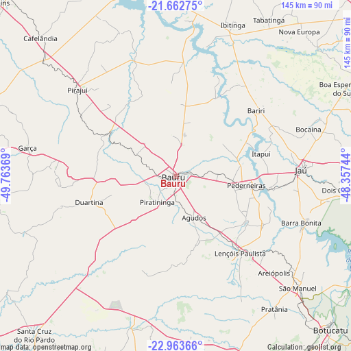
Bauru GPS coordinates[2]
22° 18' 52.992" South, 49° 3' 38.016" West
| Map corner | latitude | longitude |
|---|---|---|
| Upper-left | -21.66275°, | -49.76369° |
| Center: | -22.31472°, | -49.06056° |
| Lower-right: | -22.96366°, | -48.35744° |
| Map W x H: | 144.6×144.7 km | = 89.9×89.9mi |
| max Lat: | 2.81972° ⇑72.1% North |
| Bauru: | -22.31472° |
| min Lat: | ⇓27.9% South -33.69111° |
| min Long | Bauru | max Long |
| -72.89583° | -49.06056° | -32.41083° |
| W 28.2%⇐ | ⇒71.8% E |
Elevation
Elevation of Bauru is 530 m = 1739 ft, and this is 149.1 m = 489 ft above average elevation for this country.
| Max E: |
1603 m = 5259 ft | 34.3% |
| Bauru | 530 m 1739 ft | |
| Avg. | 380.9 m = 1250 ft | |
Min E: |
0 m = 0 ft | 65.7% |
See also: Bauru elevation on elevation.city.
Geographical zone
Bauru is located in South Torrid zone (between Equator and Tropic of Capricorn). Distance of this Southern Tropic circle is 124.8 km =77.5 mi to South.| Distance of | km | miles | from Bauru |
|---|---|---|---|
| Equator | 2481.2 | 1541.7 | to North |
| Tropic Capricorn | 124.8 | 77.5 | to South |
| Antarctic Circle | 4920 | 3057.1 | to South |
| South Pole | 7525.9 | 4676.4 | to South |


Nearby cities:
15 places around Bauru: (largest is in red/bold)
• Agudos
18.7 km =11.6 mi,  156°
156°
• Bariri
42.4 km =26.3 mi,  50°
50°
• Barra Bonita
55.4 km =34.4 mi,  111°
111°
• Boracéia
32 km =19.9 mi,  64°
64°
• Duartina
37 km =23 mi,  252°
252°
• Garça
62.4 km =38.8 mi,  280°
280°
• Ibitinga
66.4 km =41.3 mi,  21°
21°
• Igaraçu do Tietê
56 km =34.8 mi, 112°
• Itapuí
36.3 km =22.6 mi,  75°
75°
• Jaú
51.8 km =32.2 mi,  87°
87°
• Lençóis Paulista
41.4 km =25.7 mi,  139°
139°
• Macatuba
41.5 km =25.8 mi,  120°
120°
• Pederneiras
29.7 km =18.5 mi,  97°
97°
• Pirajuí
53.9 km =33.5 mi,  310°
310°
• São Manuel
68.4 km =42.5 mi,  132°
132°
Sources, notices
• [Note1] Compared only with cities in Brazil existing in our database
• [Src1] Map data: © OpenStreetMap contributors (CC-BY-SA)
• [Src2] Other city data from geonames.org with taken over terms of usage.
• [Src3] Geographical zone / Annual Mean Temperature by Robert A. Rohde @ Wikipedia
