Duartina geodata
Duartina (São Paulo) is a populated place; located in Brazil in America/Sao_Paulo (GMT-3) time zone. With population of 11,902 people, there are 1488 cities with bigger population in this country. Compared to other cities in Brazil, 72.7% of cities are located further ↑North; 74.9% of cities are located further →East and 63.8% of cities have lower elevation than Duartina. Note1


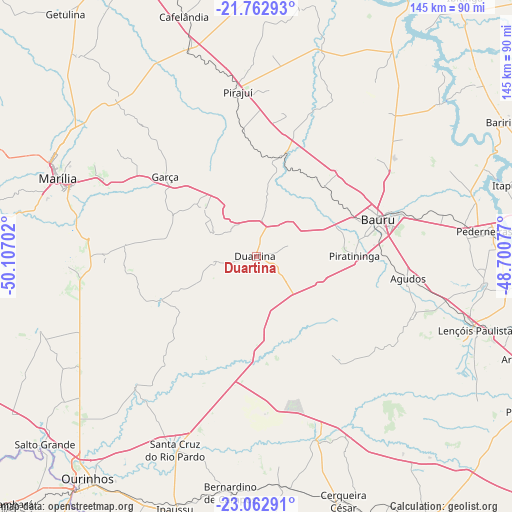
Duartina GPS coordinates[2]
22° 24' 51.984" South, 49° 24' 14.004" West
| Map corner | latitude | longitude |
|---|---|---|
| Upper-left | -21.76293°, | -50.10702° |
| Center: | -22.41444°, | -49.40389° |
| Lower-right: | -23.06291°, | -48.70077° |
| Map W x H: | 144.5×144.5 km | = 89.8×89.8mi |
| max Lat: | 2.81972° ⇑72.7% North |
| Duartina: | -22.41444° |
| min Lat: | ⇓27.3% South -33.69111° |
| min Long | Duartina | max Long |
| -72.89583° | -49.40389° | -32.41083° |
| W 25.1%⇐ | ⇒74.9% E |
Elevation
Elevation of Duartina is 515 m = 1690 ft, and this is 134.1 m = 440 ft above average elevation for this country.
| Max E: |
1603 m = 5259 ft | 36.2% |
| Duartina | 515 m 1690 ft | |
| Avg. | 380.9 m = 1250 ft | |
Min E: |
0 m = 0 ft | 63.8% |
See also: Brazil elevation on elevation.city.
Geographical zone
Duartina is located in South Torrid zone (between Equator and Tropic of Capricorn). Distance of this Southern Tropic circle is 113.7 km =70.6 mi to South.| Distance of | km | miles | from Duartina |
|---|---|---|---|
| Equator | 2492.3 | 1548.6 | to North |
| Tropic Capricorn | 113.7 | 70.6 | to South |
| Antarctic Circle | 4908.9 | 3050.2 | to South |
| South Pole | 7514.8 | 4669.5 | to South |


Nearby cities:
15 places around Duartina: (largest is in red/bold)
• Agudos
43.2 km =26.8 mi,  98°
98°
• Bauru
37 km =23 mi,  72°
72°
• Bernardino de Campos
66.9 km =41.6 mi,  186°
186°
• Boracéia
68.8 km =42.8 mi, 69°
• Cafelândia
71.3 km =44.3 mi,  342°
342°
• Cerqueira César
73.2 km =45.5 mi,  160°
160°
• Garça
34.5 km =21.4 mi,  311°
311°
• Ipauçu
75 km =46.6 mi,  197°
197°
• Itapuí
73.2 km =45.5 mi, 74°
• Lençóis Paulista
65.3 km =40.6 mi,  108°
108°
• Macatuba
71.8 km =44.6 mi, 97°
• Marília
60 km =37.3 mi,  291°
291°
• Pederneiras
65 km =40.4 mi,  83°
83°
• Pirajuí
46.6 km =29 mi,  353°
353°
• Santa Cruz do Rio Pardo
58.8 km =36.5 mi, 203°
Sources, notices
• [Note1] Compared only with cities in Brazil existing in our database
• [Src1] Map data: © OpenStreetMap contributors (CC-BY-SA)
• [Src2] Other city data from geonames.org with taken over terms of usage.
• [Src3] Geographical zone / Annual Mean Temperature by Robert A. Rohde @ Wikipedia
