Garça geodata
Garça (São Paulo) is a populated place; located in Brazil in America/Sao_Paulo (GMT-3) time zone. With population of 41,302 people, there are 511 cities with bigger population in this country. Compared to other cities in Brazil, 71.1% of cities are located further ↑North; 76.5% of cities are located further →East and 79% of cities have lower elevation than Garça. Note1


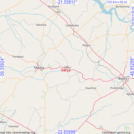
Garça GPS coordinates[2]
22° 12' 38.016" South, 49° 39' 21.996" West
| Map corner | latitude | longitude |
|---|---|---|
| Upper-left | -21.55811°, | -50.35924° |
| Center: | -22.21056°, | -49.65611° |
| Lower-right: | -22.85999°, | -48.95299° |
| Map W x H: | 144.8×144.8 km | = 90×90mi |
| max Lat: | 2.81972° ⇑71.1% North |
| Garça: | -22.21056° |
| min Lat: | ⇓28.9% South -33.69111° |
| min Long | Garça | max Long |
| -72.89583° | -49.65611° | -32.41083° |
| W 23.5%⇐ | ⇒76.5% E |
Elevation
Elevation of Garça is 678 m = 2224 ft, and this is 297.1 m = 975 ft above average elevation for this country.
| Max E: |
1603 m = 5259 ft | 21% |
| Garça | 678 m 2224 ft | |
| Avg. | 380.9 m = 1250 ft | |
Min E: |
0 m = 0 ft | 79% |
See also: Garça elevation on elevation.city.
Geographical zone
Garça is located in South Torrid zone (between Equator and Tropic of Capricorn). Distance of this Southern Tropic circle is 136.3 km =84.7 mi to South.| Distance of | km | miles | from Garça |
|---|---|---|---|
| Equator | 2469.6 | 1534.5 | to North |
| Tropic Capricorn | 136.3 | 84.7 | to South |
| Antarctic Circle | 4931.6 | 3064.4 | to South |
| South Pole | 7537.5 | 4683.6 | to South |


Nearby cities:
15 places around Garça: (largest is in red/bold)
• Agudos
74.5 km =46.3 mi,  112°
112°
• Bauru
62.4 km =38.8 mi,  100°
100°
• Bernardino de Campos
91.2 km =56.7 mi,  168°
168°
• Boracéia
90.3 km =56.1 mi,  88°
88°
• Borborema
89 km =55.3 mi,  42°
42°
• Cafelândia
45.6 km =28.3 mi,  5°
5°
• Duartina
34.5 km =21.4 mi,  131°
131°
• Lins
59.8 km =37.2 mi,  351°
351°
• Marília
29.8 km =18.5 mi,  269°
269°
• Ourinhos
88.2 km =54.8 mi,  194°
194°
• Palmital
86.4 km =53.7 mi,  221°
221°
• Pirajuí
31.2 km =19.4 mi, 41°
• Pompéia
54.3 km =33.7 mi,  282°
282°
• Promissão
77.8 km =48.3 mi,  344°
344°
• Santa Cruz do Rio Pardo
76.6 km =47.6 mi,  178°
178°
Sources, notices
• [Note1] Compared only with cities in Brazil existing in our database
• [Src1] Map data: © OpenStreetMap contributors (CC-BY-SA)
• [Src2] Other city data from geonames.org with taken over terms of usage.
• [Src3] Geographical zone / Annual Mean Temperature by Robert A. Rohde @ Wikipedia
