Frutal geodata
Frutal (Minas Gerais) is a populated place; located in Brazil in America/Sao_Paulo (GMT-3) time zone. With population of 40,931 people, there are 517 cities with bigger population in this country. Compared to other cities in Brazil, 57.3% of cities are located further ↑North; 71% of cities are located further →East and 63.3% of cities have lower elevation than Frutal. Note1


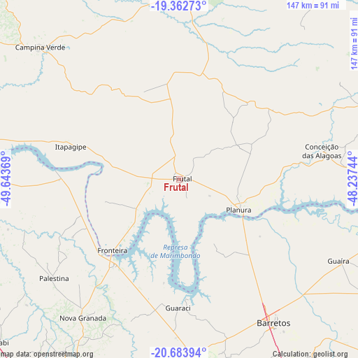
Frutal GPS coordinates[2]
20° 1' 28.992" South, 48° 56' 26.016" West
| Map corner | latitude | longitude |
|---|---|---|
| Upper-left | -19.36273°, | -49.64369° |
| Center: | -20.02472°, | -48.94056° |
| Lower-right: | -20.68394°, | -48.23744° |
| Map W x H: | 146.9×146.9 km | = 91.3×91.3mi |
| max Lat: | 2.81972° ⇑57.3% North |
| Frutal: | -20.02472° |
| min Lat: | ⇓42.7% South -33.69111° |
| min Long | Frutal | max Long |
| -72.89583° | -48.94056° | -32.41083° |
| W 29%⇐ | ⇒71% E |
Elevation
Elevation of Frutal is 511 m = 1677 ft, and this is 130.1 m = 427 ft above average elevation for this country.
| Max E: |
1603 m = 5259 ft | 36.7% |
| Frutal | 511 m 1677 ft | |
| Avg. | 380.9 m = 1250 ft | |
Min E: |
0 m = 0 ft | 63.3% |
See also: Frutal elevation on elevation.city.
Geographical zone
Frutal is located in South Torrid zone (between Equator and Tropic of Capricorn). Distance of this Southern Tropic circle is 379.4 km =235.7 mi to South.| Distance of | km | miles | from Frutal |
|---|---|---|---|
| Equator | 2226.5 | 1383.5 | to North |
| Tropic Capricorn | 379.4 | 235.7 | to South |
| Antarctic Circle | 5174.6 | 3215.3 | to South |
| South Pole | 7780.5 | 4834.6 | to South |


Nearby cities:
15 places around Frutal: (largest is in red/bold)
• Barretos
70.8 km =44 mi,  146°
146°
• Campina Verde
78.8 km =49 mi,  313°
313°
• Cardoso
101.9 km =63.3 mi,  266°
266°
• Conceição das Alagoas
59 km =36.7 mi,  78°
78°
• Guapiaçu
90.5 km =56.2 mi,  198°
198°
• Guaíra
73.4 km =45.6 mi,  116°
116°
• Miguelópolis
96.4 km =59.9 mi,  100°
100°
• Monte Azul Paulista
103 km =64 mi,  162°
162°
• Nova Granada
68.7 km =42.7 mi,  214°
214°
• Olímpia
79.3 km =49.3 mi,  178°
178°
• Prata
79.8 km =49.6 mi,  1°
1°
• Riolândia
77.6 km =48.2 mi, 273°
• Severínia
88.4 km =54.9 mi,  170°
170°
• São José do Rio Preto
99.5 km =61.8 mi, 207°
• Tanabi
99.7 km =62 mi,  227°
227°
Sources, notices
• [Note1] Compared only with cities in Brazil existing in our database
• [Src1] Map data: © OpenStreetMap contributors (CC-BY-SA)
• [Src2] Other city data from geonames.org with taken over terms of usage.
• [Src3] Geographical zone / Annual Mean Temperature by Robert A. Rohde @ Wikipedia
