Sinop geodata
Sinop (Mato Grosso) is a populated place; located in Brazil in America/Cuiaba (GMT-4) time zone. With population of 116,013 people, there are 194 cities with bigger population in this country. Compared to other cities in Brazil, 62.5% of cities are located further ↓South; 94.6% of cities are located further →East and 51.9% of cities have lower elevation than Sinop. Note1


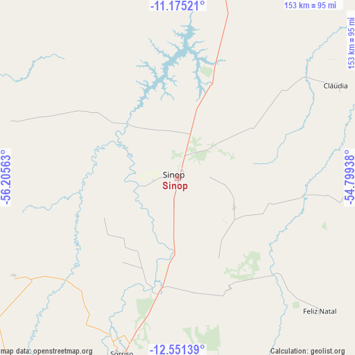
Sinop GPS coordinates[2]
11° 51' 51.012" South, 55° 30' 9" West
| Map corner | latitude | longitude |
|---|---|---|
| Upper-left | -11.17521°, | -56.20563° |
| Center: | -11.86417°, | -55.5025° |
| Lower-right: | -12.55139°, | -54.79938° |
| Map W x H: | 153×153 km | = 95.1×95.1mi |
| max Lat: | 2.81972° ⇑37.5% North |
| Sinop: | -11.86417° |
| min Lat: | ⇓62.5% South -33.69111° |
| min Long | Sinop | max Long |
| -72.89583° | -55.5025° | -32.41083° |
| W 5.4%⇐ | ⇒94.6% E |
Elevation
Elevation of Sinop is 378 m = 1240 ft, and this is 2.9 m = 10 ft below average elevation for this country.
| Max E: |
1603 m = 5259 ft | 48.1% |
| Avg. | 380.9 m = 1250 ft | |
| Sinop | 378 m = 1240 ft | |
Min E: |
0 m = 0 ft | 51.9% |
See also: Sinop elevation on elevation.city.
Geographical zone
Sinop is located in South Torrid zone (between Equator and Tropic of Capricorn). Distance of this Southern Tropic circle is 1286.7 km =799.5 mi to South.| Distance of | km | miles | from Sinop |
|---|---|---|---|
| Equator | 1319.2 | 819.7 | to North |
| Tropic Capricorn | 1286.7 | 799.5 | to South |
| Antarctic Circle | 6082 | 3779.2 | to South |
| South Pole | 8687.9 | 5398.4 | to South |


Nearby cities:
12 places around Sinop: (largest is in red/bold)
• Alta Floresta
230.1 km =143 mi,  343°
343°
• Arenápolis
322.2 km =200.2 mi,  206°
206°
• Barra do Bugres
400.2 km =248.7 mi, 206°
• Chapada dos Guimarães
400.8 km =249 mi,  183°
183°
• Cuiabá
419.9 km =260.9 mi,  188°
188°
• Diamantino
300.8 km =186.9 mi,  199°
199°
• Lucas do Rio Verde
141.7 km =88 mi, 198°
• Nobres
329.9 km =205 mi, 195°
• Nortelândia
320.6 km =199.2 mi, 206°
• Nova Olímpia
379 km =235.5 mi, 210°
• Rosário Oeste
345.3 km =214.6 mi, 196°
• Várzea Grande
426 km =264.7 mi, 189°
Sources, notices
• [Note1] Compared only with cities in Brazil existing in our database
• [Src1] Map data: © OpenStreetMap contributors (CC-BY-SA)
• [Src2] Other city data from geonames.org with taken over terms of usage.
• [Src3] Geographical zone / Annual Mean Temperature by Robert A. Rohde @ Wikipedia
