Nobres geodata
Nobres (Mato Grosso) is a populated place; located in Brazil in America/Cuiaba (GMT-4) time zone. With population of 12,009 people, there are 1475 cities with bigger population in this country. Compared to other cities in Brazil, 56.8% of cities are located further ↓South; 95.6% of cities are located further →East and 60.9% of cities have higher elevation than Nobres. Note1


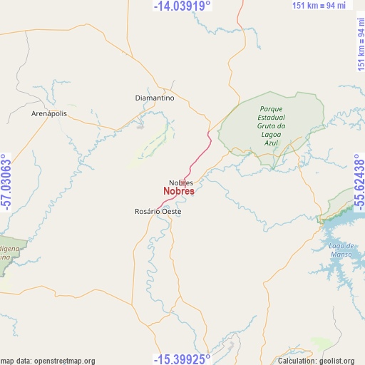
Nobres GPS coordinates[2]
14° 43' 13.008" South, 56° 19' 39" West
| Map corner | latitude | longitude |
|---|---|---|
| Upper-left | -14.03919°, | -57.03063° |
| Center: | -14.72028°, | -56.3275° |
| Lower-right: | -15.39925°, | -55.62438° |
| Map W x H: | 151.2×151.2 km | = 94×94mi |
| max Lat: | 2.81972° ⇑43.2% North |
| Nobres: | -14.72028° |
| min Lat: | ⇓56.8% South -33.69111° |
| min Long | Nobres | max Long |
| -72.89583° | -56.3275° | -32.41083° |
| W 4.4%⇐ | ⇒95.6% E |
Elevation
Elevation of Nobres is 200 m = 656 ft, and this is 180.9 m = 594 ft below average elevation for this country.
| Max E: |
1603 m = 5259 ft | 60.9% |
| Avg. | 380.9 m = 1250 ft | |
| Nobres | 200 m = 656 ft | |
Min E: |
0 m = 0 ft | 39.1% |
See also: Brazil elevation on elevation.city.
Geographical zone
Nobres is located in South Torrid zone (between Equator and Tropic of Capricorn). Distance of this Southern Tropic circle is 969.2 km =602.2 mi to South.| Distance of | km | miles | from Nobres |
|---|---|---|---|
| Equator | 1636.7 | 1017 | to North |
| Tropic Capricorn | 969.2 | 602.2 | to South |
| Antarctic Circle | 5764.4 | 3581.8 | to South |
| South Pole | 8370.3 | 5201.1 | to South |


Nearby cities:
15 places around Nobres: (largest is in red/bold)
• Arenápolis
63.4 km =39.4 mi,  298°
298°
• Barra do Bugres
99.7 km =62 mi,  246°
246°
• Barão de Melgaço
168.4 km =104.6 mi,  166°
166°
• Chapada dos Guimarães
103.1 km =64.1 mi,  142°
142°
• Cuiabá
100.5 km =62.4 mi, 165°
• Diamantino
36.9 km =22.9 mi,  339°
339°
• Jaciara
201 km =124.9 mi,  133°
133°
• Lucas
184.3 km =114.5 mi, 166°
• Lucas do Rio Verde
188.6 km =117.2 mi,  13°
13°
• Nortelândia
59.1 km =36.7 mi, 300°
• Nova Olímpia
103.6 km =64.4 mi,  265°
265°
• Poconé
173.7 km =107.9 mi,  190°
190°
• Rosário Oeste
16.8 km =10.4 mi,  219°
219°
• Santo Antônio do Leverger
130.2 km =80.9 mi, 168°
• Várzea Grande
105.1 km =65.3 mi, 168°
Sources, notices
• [Note1] Compared only with cities in Brazil existing in our database
• [Src1] Map data: © OpenStreetMap contributors (CC-BY-SA)
• [Src2] Other city data from geonames.org with taken over terms of usage.
• [Src3] Geographical zone / Annual Mean Temperature by Robert A. Rohde @ Wikipedia
