Nortelândia geodata
Nortelândia (Mato Grosso) is a populated place; located in Brazil in America/Cuiaba (GMT-4) time zone. With population of 9,634 people, there are 1676 cities with bigger population in this country. Compared to other cities in Brazil, 57.4% of cities are located further ↓South; 96.2% of cities are located further →East and 58.2% of cities have higher elevation than Nortelândia. Note1


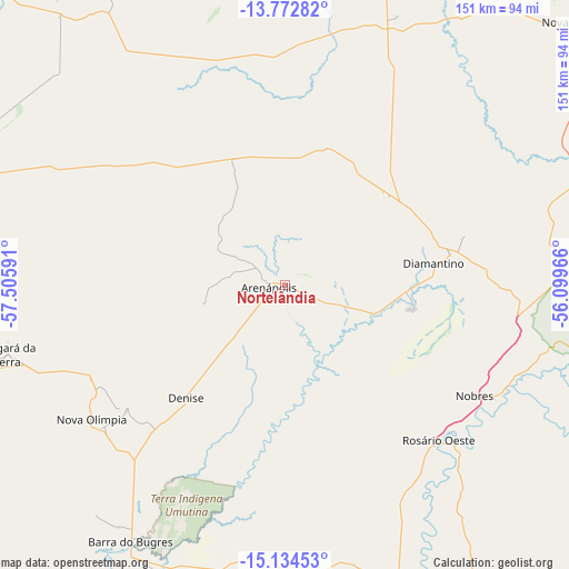
Nortelândia GPS coordinates[2]
14° 27' 16.992" South, 56° 48' 10.008" West
| Map corner | latitude | longitude |
|---|---|---|
| Upper-left | -13.77282°, | -57.50591° |
| Center: | -14.45472°, | -56.80278° |
| Lower-right: | -15.13453°, | -56.09966° |
| Map W x H: | 151.4×151.4 km | = 94.1×94.1mi |
| max Lat: | 2.81972° ⇑42.6% North |
| Nortelândia: | -14.45472° |
| min Lat: | ⇓57.4% South -33.69111° |
| min Long | Nortelândia | max Long |
| -72.89583° | -56.80278° | -32.41083° |
| W 3.8%⇐ | ⇒96.2% E |
Elevation
Elevation of Nortelândia is 230 m = 755 ft, and this is 150.9 m = 495 ft below average elevation for this country.
| Max E: |
1603 m = 5259 ft | 58.2% |
| Avg. | 380.9 m = 1250 ft | |
| Nortelândia | 230 m = 755 ft | |
Min E: |
0 m = 0 ft | 41.8% |
See also: Brazil elevation on elevation.city.
Geographical zone
Nortelândia is located in South Torrid zone (between Equator and Tropic of Capricorn). Distance of this Southern Tropic circle is 998.7 km =620.6 mi to South.| Distance of | km | miles | from Nortelândia |
|---|---|---|---|
| Equator | 1607.2 | 998.7 | to North |
| Tropic Capricorn | 998.7 | 620.6 | to South |
| Antarctic Circle | 5794 | 3600.2 | to South |
| South Pole | 8399.8 | 5219.4 | to South |


Nearby cities:
15 places around Nortelândia: (largest is in red/bold)
• Arenápolis
4.7 km =2.9 mi,  276°
276°
• Barra do Bugres
79.8 km =49.6 mi,  210°
210°
• Barão de Melgaço
213.2 km =132.5 mi,  155°
155°
• Chapada dos Guimarães
159.1 km =98.9 mi,  134°
134°
• Cuiabá
147.8 km =91.8 mi,  149°
149°
• Diamantino
38.7 km =24 mi,  82°
82°
• Jaciara
258.7 km =160.7 mi, 130°
• Lucas
228.7 km =142.1 mi, 155°
• Lucas do Rio Verde
180.9 km =112.4 mi,  31°
31°
• Nobres
59.1 km =36.7 mi,  120°
120°
• Nova Olímpia
64.6 km =40.1 mi,  233°
233°
• Poconé
201.3 km =125.1 mi,  174°
174°
• Rosário Oeste
58.6 km =36.4 mi,  136°
136°
• Santo Antônio do Leverger
175.2 km =108.9 mi, 153°
• Várzea Grande
150.8 km =93.7 mi, 151°
Sources, notices
• [Note1] Compared only with cities in Brazil existing in our database
• [Src1] Map data: © OpenStreetMap contributors (CC-BY-SA)
• [Src2] Other city data from geonames.org with taken over terms of usage.
• [Src3] Geographical zone / Annual Mean Temperature by Robert A. Rohde @ Wikipedia
